 Catálogo REDIAM
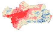
REDIAM. WMS Propiedades físicas del suelo en el marco del estudio de la Biomasa Forestal de Andalucía
Servicio WMS correspondiente al Raster de 100x100m de variables físicas del suelo, clasificación textural, limo, arcilla, arena, tierra fina y profundidad de suelo, para lo que se ha utilizado la información facilitada por la Consejería de Agricultura y Pesca y calculados bajo el estudio "Sistema de Inferencia Espacial de las propiedades Físico-Químicas e Hidráulicas de Suelos de Andalucía, calculado para el estudio Biomasa Forestal en Andalucía. Modelos de existencias, crecimiento y producción. Coníferas. Nodo de la Red de Información Ambiental de Andalucía. Junta de Andalucía. Integrado en la Infraestructura de Datos Espaciales de Andalucía, siguiendo las directrices del Sistema Cartográfico de Andalucía.
Simple
- Date (Publication)
- 2014-01-31T10:05:10
- Status
- Completed
- Point of contact
-
Organisation name Individual name Electronic mail address Role Consejería de Medio Ambiente y Ordenación del Territorio. Junta de Andalucía
--
Point of contact
- Theme
-
-
WMS
-
REDIAM
-
Andalucía
-
textura
-
limo
-
arcilla
-
arena
-
tierra y profundidad
-
suelo
-
IDEAndalucia
-
IDEE_INSPIRE
-
humanInteractionService
-
- Use limitation
-
Este servicio se puede usar de modo libre y gratuito siempre que se mencione a los autores y propietarios de la información
- Access constraints
- Other restrictions
- Use constraints
- Other restrictions
- Other constraints
-
Creative Commons Reconocimiento 4.0 (CC BY 4.0)
- Service Type
- OGC:WMS
- Service Version
-
1.1.1
- Fees
-
Gratuito
))
- Coupling Type
- Tight
- Contains Operations
- Distribution format
-
Name Version WMS
1.1.1
- OnLine resource
-
Protocol Linkage Name OGC:WMS-1.1.1-http-get-map
http://www.juntadeandalucia.es/medioambiente/mapwms/REDIAM_propiedades_fisicas_suelo_biomasa_forestal?
- OnLine resource
-
Protocol Linkage Name WWW:LINK-1.0-http--link
http://www.juntadeandalucia.es/medioambiente/site/rediam/menuitem.04dc44281e5d53cf8ca78ca731525ea0/?vgnextoid=cd0203635f1ce310VgnVCM2000000624e50aRCRD&vgnextchannel=dad1c3cbbff7f310VgnVCM1000001325e50aRCRD&vgnextfmt=rediam&lr=lang_es Ficha servicio Canal REDIAM
- OnLine resource
-
Protocol Linkage Name GLG:KML-2.0-http-get-map
http://www.juntadeandalucia.es/medioambiente/portal_web/rediam/productos/ServiciosOGC/KML/Cartografia_ambiental/Sistemas_productivos/propiedades_fisicas_suelo.kml Fichero KML
- Hierarchy level
- Service
Attributes
Conformance result
- Date (Publication)
- 2010-12-08publication
Citation identifier
- Explanation
-
Consultar el reglamento mencionado
- Pass
- Yes
Conformance result
- Date (Publication)
- 2010-12-08
Citation identifier
- Explanation
-
Consultar el reglamento mencionado
- Pass
- Yes
- File identifier
- 149c63d488125c588214d685f6897b7314e50ffe XML
- Metadata language
- Spanish; Castilian
- Character set
- UTF8
- Hierarchy level
- Service
- Date stamp
- 2022-09-01T10:40:35Z
- Metadata standard name
-
ISO 19119/2005
- Metadata standard version
-
1.0
- Metadata author
-
Organisation name Individual name Electronic mail address Role Consejería de Sostenibilidad y Medio Ambiente. Junta de Andalucía
--
Point of contact
Overviews

Spatial extent
Provided by
