 Catálogo REDIAM
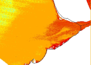
REDIAM. WMS Datos de Transparencia (m) del agua que cubren el curso bajo del río Guadalquivir, medida mediante disco de Secchi (2009-2010)
Servicio WMS correspondiente al conjunto de imágenes de transparencia del agua (metros de disco de Secchi) que cubren el curso bajo del río Guadalquivir, desde el término municipal de Alcolea del Río hasta su desembocadura. Datos obtenidos a partir de imágenes corregidas geométrica y atmosféricamente del satélite Landsat 5 captada por el sensor TM (Thematic Mapper) durante el periodo 2009 a 2010. Con la medida de este parámetro se obtiene la profundidad de penetración de la luz en el agua, profundidad que está determinada por la cantidad de materia, tanto suspendida como disuelta, presente en el agua. La medida de la transparencia de la columna de agua es importante para identificar las zonas óptimas para el desarrollo de la actividad fotosintética y por tanto de la vida acuática. Nodo de la Red de Información Ambiental de Andalucía. Junta de Andalucía. Integrado en la Infraestructura de Datos Espaciales de Andalucía, siguiendo las directrices del Sistema Cartográfico de Andalucía.
Simple
- Date (Revision)
- 2013-01-15T14:56:31
- Status
- Completed
- Point of contact
-
Organisation name Individual name Electronic mail address Role Consejería de Medio Ambiente y Ordenación del Territorio. Junta de Andalucía
--
Point of contact
- Theme
-
-
WMS
-
Andalucía
-
REDIAM
-
calidad del agua
-
imagen de satélite
-
sensor
-
satélite de observación
-
teledetección
-
humanInteractionService
-
IDEAndalucia
-
- Use limitation
-
Este servicio se puede usar de modo libre y gratuito siempre que se mencione a los autores y propietarios de la información
- Access constraints
- Other restrictions
- Use constraints
- Other restrictions
- Other constraints
-
Creative Commons Reconocimiento 4.0 (CC BY 4.0)
- Service Type
- OGC:WMS
- Service Version
-
1.1.1
- Fees
-
Gratuito
))
- Coupling Type
- Tight
- Contains Operations
- Distribution format
-
Name Version WMS
1.1.1
- OnLine resource
-
Protocol Linkage Name OGC:WMS-1.1.1-http-get-map
http://www.juntadeandalucia.es/medioambiente/mapwms/REDIAM_datos_transparencia_bajo_guadalquivir?
- OnLine resource
-
Protocol Linkage Name GLG:KML-2.0-http-get-map
http://www.juntadeandalucia.es/medioambiente/portal_web/rediam/productos/ServiciosOGC/KML/Cartografia_ambiental/Ambitos_interes_ambiental/Indicadores_calidad_agua_litoral/transparencia_bajo_guadalquivir.kml KML servicio
- OnLine resource
-
Protocol Linkage Name WWW:LINK-1.0-http--link
http://www.juntadeandalucia.es/medioambiente/site/rediam/menuitem.04dc44281e5d53cf8ca78ca731525ea0/?vgnextoid=0922161630eb5310VgnVCM2000000624e50aRCRD&vgnextchannel=3edfc89226be4310VgnVCM1000001325e50aRCRD&vgnextfmt=rediam&lr=lang_es Ficha servicio Canal REDIAM
- Hierarchy level
- Service
Attributes
Conformance result
- Date (Publication)
- 2010-12-08
Citation identifier
- Explanation
-
Consultar el reglamento mencionado
- Pass
- Yes
- File identifier
- 28565e468a248a7a8e372309724721a8b90be112 XML
- Metadata language
- Spanish; Castilian
- Character set
- UTF8
- Hierarchy level
- Service
- Date stamp
- 2022-09-01T12:04:27
- Metadata standard name
-
ISO 19119/2005
- Metadata standard version
-
1.0
- Metadata author
-
Organisation name Individual name Electronic mail address Role Consejería de Sostenibilidad, Medio Ambiente y Economía Azul. Junta de Andalucía
--
Point of contact
Overviews

Spatial extent
Provided by
