 Catálogo REDIAM
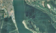
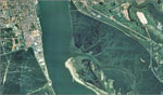
Ortofotografía desembocadura del Río Guadiana (Portugal Algarve - Andalucía), 2000
Ortofoto de la Desembocadura del Río Guadiana (Algarve-Andalucía), generada a partir del vuelo fotogramétrico color, de escala 1:20.000, de 2000.(V052_of)
Simple
- Date (Creation)
- 2000-05-01
- Date (Revision)
- 2008-02-29
- Citation identifier
- Sin identificador
- Presentation form
- Digital image
- Purpose
-
Obtención de una base de referencia cartográfica (MDT y Ortofoto), para el SIG de la desembocadura del Guadiana (Interreg IIC. Gestión Integrada del Estuario del Guadiana), tanto en sistema de referencia español como en portugués.
- Status
- Completed
- Point of contact
-
Organisation name Individual name Electronic mail address Role Consejería de Medio Ambiente y Ordenación del Territorio. Junta de Andalucía
Author
-
Observación del Territorio
-
-
Observación del Territorio. Producto primario
-
- Theme
-
-
Fotografía aérea
-
Fotogrametría
-
Vuelo de bajo nivel
-
IDEAndalucia
-
Opendata
-
-
GEMET - INSPIRE themes, version 1.0
-
-
Ortoimágenes
-
- Access constraints
- Other restrictions
- Use constraints
- Other restrictions
- Other constraints
-
Creative Commons Attribution 4.0 International Public License (CC BY 4.0)
- Spatial representation type
- Grid
- Language
- Spanish; Castilian
- Character set
- UTF8
- Topic category
-
- Imagery base maps earth cover
))
- Supplemental Information
-
01020102
- Reference system identifier
- EPSG:23030
- Reference system identifier
- INSPIRE RS registry / http://www.opengis.net/def/crs/EPSG/0/4258
- Distribution format
-
Name Version ECW
MrSid
- Units of distribution
-
Servicio WMS
- OnLine resource
-
Protocol Linkage Name OGC:WMS-1.3.0-http-get-map
http://www.juntadeandalucia.es/medioambiente/mapwms/REDIAM_Ortofoto_Guadiana_InterregII_2000 REDIAM. Vuelo Fotogramétrico de la Desembocadura del Río Guadiana (Algarve-Andalucía), COLOR Escala 1:20.000 de 2000. - Ortofoto 0.5m (RGB).
- Units of distribution
-
Ficha WMS
- OnLine resource
-
Protocol Linkage Name OGC:WMS-1.3.0-http-get-map
http://www.juntadeandalucia.es/medioambiente/site/rediam/menuitem.04dc44281e5d53cf8ca78ca731525ea0/?vgnextoid=01a4826c494cf110VgnVCM1000001325e50aRCRD&vgnextchannel=90e122ad8470f210VgnVCM1000001325e50aRCRD&vgnextfmt=rediam&lr=lang_es WMS Ortofoto de la Desembocadura del Río Guadiana (Algarve-Andalucía) color (RGB) de 2000
- Units of distribution
-
Datos en descarga
- OnLine resource
-
Protocol Linkage Name WWW:LINK-1.0-http--related
http://descargasrediam.cica.es/repo/s/RUR?path=%2F01_CARACTERIZACION_TERRITORIO%2F02_BASES_REF_ORTOFOTOS_ORTOIMAGENES%2F01_ORTOFOTOS%2F02_PROYECTOS_LOCALES%2F2000_06_01_HU_Guadiana_0.50m_V052_of Descarga Ortofotografía desembocadura del Río Guadiana (Portugal Algarve - Andalucía), 2000 (2000_06_01_HU_Guadiana_0.50m_V052_of)
- Hierarchy level
- Dataset
Conformance result
- Date (Publication)
- 2010-12-08
Citation identifier
- Explanation
-
Consultar el reglamento mencionado
- Pass
- Yes
- Statement
-
Para generar la ortofotografía se utiliza la información proporcionada por el vuelo fotogramétrico, el apoyo de campo, la aerotriangulación y el modelo digital de elevaciones.
- Description
-
Vuelo fotogramétrico analógico a partir de la escala 1:20.000 del año 2000 en Color de la Consejería de Medio Ambiente.
- File identifier
- 4662edb1-6ab8-462a-8aa2-dc15350409ad XML
- Metadata language
- Spanish; Castilian
- Character set
- UTF8
- Hierarchy level
- Dataset
- Date stamp
- 2022-09-01T12:08:40
- Metadata standard name
-
ISO 19115 "NEM"
- Metadata standard version
-
2003 "1.0"
- Metadata author
-
Organisation name Individual name Electronic mail address Role Consejería de Sostenibilidad, Medio Ambiente y Economía Azul. Junta de Andalucía
Author
Overviews
Spatial extent
Provided by
