 Catálogo REDIAM
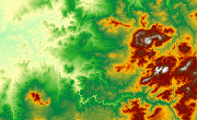
MDE PN Sierra de Andújar (Jaén), 2000
Modelo Digital de Elevaciones del ámbito del Parque Natural Sierra de Andújar. (Información Topográfica). (806V_el)
Simple
- Date (Creation)
- 2009-01-20
- Date (Revision)
- 2008-02-29
- Citation identifier
- Sin identificador
- Presentation form
- Digital model
- Purpose
-
Base de Cartográfica de Referencia Altimétrica y obtención de Mapas derivados: Pendientes y Orientaciones.
- Status
- Historical archive
- Point of contact
-
Organisation name Individual name Electronic mail address Role Consejería de Medio Ambiente y Ordenación del Territorio. Junta de Andalucía
Author
-
Observación del Territorio
-
-
Observación del Territorio. Producto primario
-
- Theme
-
-
Fotografía aérea
-
Fotogrametría
-
IDEAndalucia
-
Opendata
-
-
GEMET - INSPIRE themes, version 1.0
-
-
Elevaciones
-
-
Registro de temas REDIAM
-
-
Teledetección y caracterización del territorio
-
- Access constraints
- Other restrictions
- Use constraints
- Other restrictions
- Other constraints
-
Creative Commons Attribution 4.0 International Public License (CC BY 4.0)
- Spatial representation type
- Grid
- Language
- Spanish; Castilian
- Character set
- UTF8
- Topic category
-
- Elevation
))
- Supplemental Information
-
01070102
- Reference system identifier
- EPSG:25830
- Reference system identifier
- INSPIRE RS registry / http://www.opengis.net/def/crs/EPSG/0/4258
- Distribution format
-
Name Version ASCIIXYZ
TIFF
- Units of distribution
-
Datos en descarga
- OnLine resource
-
Protocol Linkage Name WWW:LINK-1.0-http--link
https://portalrediam.cica.es/descargas?path=%2F01_CARACTERIZACION_TERRITORIO%2F07_BASES_REF_ELEV%2F01_ELEVACIONES%2F02_PROYECTOS_LOCALES%2F2000_03_16_JA_Andujar_10m_806V_el Descarga MDE PN Sierra de Andújar (Jaén), 2000
- Hierarchy level
- Dataset
Conformance result
- Date (Publication)
- 2010-12-08
Citation identifier
- Explanation
-
Consultar el reglamento mencionado
- Pass
- Yes
- Statement
-
Escaneado de Hojas MTA 1:10.000 de Andalucía. Digitalización de curvas de nivel de todas las hojas. Fusión de líneas de curvas de nivel. Generación de MDE TIN. Generación GRID a resolución 75x75m a partir del TIN. Exportación a formato BIP. Nota: Posteriormente se han obtenido los mapas de Pendientes, Orientaciones.
- Description
-
Consejería de Medio Ambiente.
- File identifier
- 47cd842b-d6c2-4946-8f01-21bb509a2d94 XML
- Metadata language
- Spanish; Castilian
- Character set
- UTF8
- Hierarchy level
- Dataset
- Date stamp
- 2022-10-20T09:04:46
- Metadata standard name
-
ISO 19115 "NEM"
- Metadata standard version
-
2003 "1.0"
- Metadata author
-
Organisation name Individual name Electronic mail address Role Consejería de Sostenibilidad, Medio Ambiente y Economía Azul. Junta de Andalucía
Author
Overviews

Spatial extent
Provided by
