 Catálogo REDIAM
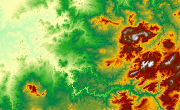
MDE PN Doñana (Huelva), 2001
Modelo Digital de Elevaciones: Terreno (MDT) del Parque Natural de Doñana (Sevilla-Huelva), generado a partir del vuelo LIDAR, de 2001. (V107_el)
Simple
- Date (Creation)
- 2001-01-01
- Date (Revision)
- 2008-02-29
- Presentation form
- Digital model
- Purpose
-
Base Cartográfica de Referencia Altimétrica del ámbito Doñana y estudios de Modelización Hidrológica-Hidráulica.
- Status
- Historical archive
- Point of contact
-
Organisation name Individual name Electronic mail address Role Ministerio de Medio Ambiente y Medio Rural y Marino. Gobierno de España.
Author
-
Observación del Territorio
-
-
Observación del Territorio. Producto primario
-
- Theme
-
-
Fotografía aérea
-
Fotogrametría
-
Vuelo de bajo nivel
-
Opendata
-
-
GEMET - INSPIRE themes, version 1.0
-
-
Elevaciones
-
-
Registro de temas REDIAM
-
-
Teledetección y caracterización del territorio
-
- Use limitation
-
Para saber la licencia hay que mirar el campo de acceso y uso.
- Access constraints
- Other restrictions
- Use constraints
- Other restrictions
- Other constraints
-
Creative Commons Attribution 4.0 International Public License
- Spatial representation type
- Grid
- Language
- Spanish; Castilian
- Character set
- UTF8
- Topic category
-
- Elevation
))
- Supplemental Information
-
01070102
- Reference system identifier
- EPSG:25830
- Reference system identifier
- INSPIRE RS registry / http://www.opengis.net/def/crs/EPSG/0/4258
- Distribution format
-
Name Version BMC
ASCIIGRID
- Units of distribution
-
Datos en descarga
- OnLine resource
-
Protocol Linkage Name WWW:LINK-1.0-http--link
https://portalrediam.cica.es/descargas?path=%2F01_CARACTERIZACION_TERRITORIO%2F07_BASES_REF_ELEV%2F01_ELEVACIONES%2F02_PROYECTOS_LOCALES%2F2001_01_01_HU_Donana_2m_V107_el Descarga MDE PN Doñana (Huelva), 2001
- Hierarchy level
- Dataset
Conformance result
- Date (Publication)
- 2010-12-08
Citation identifier
- Explanation
-
Consultar el reglamento mencionado
- Pass
- Yes
- Statement
-
Para generar el modelo digital de elevaciones se parte del vuelo LIDAR con la información GPS e IMU y se procesan los datos capturados con el sensor. A partir de los datos brutos "*.las" se realiza una clasificación de puntos. Con los puntos clasificados como terreno se genera el MDT grid. Con éstos más edificios, infraestructuras,... Se genera el MDS grid
- Description
-
Generado a partir del vuelo Lidar del año 2001 de la Confederación Hidrográfica del Guadalquivir.
- File identifier
- 4918ca39-70f1-41bb-b532-70ef6a7da03d XML
- Metadata language
- Spanish; Castilian
- Character set
- UTF8
- Hierarchy level
- Dataset
- Date stamp
- 2022-10-20T08:26:01
- Metadata standard name
-
ISO 19115 "NEM"
- Metadata standard version
-
2003 "1.0"
- Metadata author
-
Organisation name Individual name Electronic mail address Role Consejería de Sostenibilidad, Medio Ambiente y Economía Azul. Junta de Andalucía
Author
Overviews

Spatial extent
Provided by
