 Catálogo REDIAM
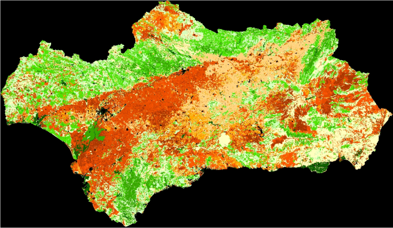
REDIAM. WMS Factor de Protección de la cubierta vegetal frente a la erosión (Factor C) en Andalucía. Año 2002
Servicio WMS correspondiente al índice de protección de la cubierta vegetal frente a la erosión (Factor C), calculado a partir de la fotointerpretación de imágenes de satélite IRS-WIFS del año 2002. El Factor C es uno de los parámetros tenidos en cuenta en la Ecuación Universal de Pérdidas de Suelo (USLE), para su cálculo se ha utilizado el Mapa de Usos y Coberturas Vegetales de Andalucía, y rangos de variación según el NDVI (Normalized Difference Vegetation Index) medido en cada pixel. Consejería de Medio Ambiente y Ordenación del Territorio. Junta de Andalucía. Nodo de la Red de Información Ambiental de Andalucía. Junta de Andalucía. Integrado en la Infraestructura de Datos Espaciales de Andalucía, siguiendo las directrices del Sistema Cartográfico de Andalucía.
Simple
- Date (Revision)
- 2012-12-18T13:37:40
- Status
- Completed
- Point of contact
-
Organisation name Individual name Electronic mail address Role Consejería de Medio Ambiente y Ordenación del Territorio. Junta de Andalucía
--
Point of contact
- Theme
-
-
WMS
-
REDIAM
-
Andalucía
-
Cubierta vegetal
-
Imagen vía satélite
-
Sensor
-
Satélite de observación
-
Teledetección
-
Tratamiento de imágenes
-
Erosión de suelos
-
humanInteractionService
-
IDEAndalucia
-
- Use limitation
-
Este servicio se puede usar de modo libre y gratuito siempre que se mencione a los autores y propietarios de la información
- Access constraints
- Other restrictions
- Use constraints
- Other restrictions
- Other constraints
-
Creative Commons Reconocimiento 4.0 (CC BY 4.0)
- Service Type
- OGC:WMS
- Service Version
-
1.1.1
- Fees
-
Gratuito
))
- Coupling Type
- Tight
- Contains Operations
- Distribution format
-
Name Version WMS
1.1.1
- OnLine resource
-
Protocol Linkage Name OGC:WMS-1.1.1-http-get-map
http://www.juntadeandalucia.es/medioambiente/mapwms/REDIAM_FPCV_factor_c_2002?
- OnLine resource
-
Protocol Linkage Name GLG:KML-2.0-http-get-map
http://www.juntadeandalucia.es/medioambiente/portal_web/rediam/productos/ServiciosOGC/KML/Cartografia_ambiental/Riesgos_naturales/factor_protec_cubierta_veg_2002.kml KML servicio
- OnLine resource
-
Protocol Linkage Name WWW:LINK-1.0-http--link
http://www.juntadeandalucia.es/medioambiente/site/rediam/menuitem.04dc44281e5d53cf8ca78ca731525ea0/?vgnextoid=021741c414564310VgnVCM2000000624e50aRCRD&vgnextchannel=94607bfaebcc4310VgnVCM2000000624e50aRCRD&vgnextfmt=rediam&lr=lang_es Ficha servicio Canal REDIAM
- Hierarchy level
- Service
Attributes
Conformance result
- Date (Publication)
- 2010-12-08
Citation identifier
- Explanation
-
Consultar el reglamento mencionado
- Pass
- Yes
- File identifier
- 5d64d4d2706b71903751139cdc4235b0b50d85e1 XML
- Metadata language
- Spanish; Castilian
- Character set
- UTF8
- Hierarchy level
- Service
- Date stamp
- 2022-09-01T12:02:32
- Metadata standard name
-
ISO 19119/2005
- Metadata standard version
-
1.0
- Metadata author
-
Organisation name Individual name Electronic mail address Role Consejería de Sostenibilidad, Medio Ambiente y Economía Azul. Junta de Andalucía
--
Point of contact
Overviews

Spatial extent
Provided by
