 Catálogo REDIAM
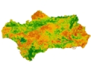
Índice de vegetación (NDVI) de Andalucía. Promedio anual, 2021 (TERRA MODIS)
Imágenes del satélite TERRA captadas por el sensor MODIS (Moderate-Resolution Imaging Spectroradiometer) a las que se les ha calculado el Índice de Vegetación de la Diferencia Normalizada (NDVI- Normalized Difference Vegetation Index), que basado en el contraste entre las bandas roja e infrarroja cercana del espectro, resalta la cobertura vegetal y su vigorosidad sobre áreas extensas. Las imágenes presentan una sola banda y una resolución espacial de 250 m. Año 2021
Simple
- Date (Creation)
- 2022-02-01
- Date (Publication)
- 2022-02-01
- Citation identifier
- Sin identificador
- Presentation form
- Digital image
- Purpose
-
El NDVI refleja las características y estado vital de la vegetación. Este parámetro permite obtener información sobre contenido de clorofila y agua en las hojas, flujo neto de dióxido de carbono, productividad neta, índice de área foliar o evapotranspiración potencial, etc. Aplicado a la imagen resalta las zonas de mayor vegetación y las de suelos desnudos. La vegetación densa y sana muestra valores altos, mientras que zonas de vegetación pobre y dispersa, o sin vegetación, destacan por sus valores bajos, que indican escasez o ausencia de actividad fotosintética. Superficies como el agua, hielo o nieve también tienen valores bajos.
- Status
- Historical archive
- Point of contact
-
Organisation name Individual name Electronic mail address Role Consejería de Agricultura, Ganadería, Pesca y Desarrollo Sostenible. Junta de Andalucía
Author
-
Observación del Territorio
-
-
Observación del Territorio. Producto derivado
-
-
Registro de temas REDIAM
-
-
Biodiversidad y Vegetación
-
Teledetección y caracterización del territorio
-
- Theme
-
-
Imagen satélite
-
Sensor
-
Satélite de observación
-
Teledetección
-
Tratamiento de imágenes
-
Índice
-
Vegetación
-
IDEAndalucia
-
NDVI
-
-
GEMET - INSPIRE themes, version 1.0
-
-
Ortoimágenes
-
- Temporal
-
-
2020
-
- Access constraints
- Other restrictions
- Use constraints
- Other restrictions
- Other constraints
-
Creative Commons Attribution 4.0 International Public License (CC BY 4.0).
Acceso y uso para el público en general permitido con reconocimiento de la información y las imágenes usadas.
Acknowledgement: "National Aeronautics and Space Administration (NASA). Original Data distributed by the Land Processes Distributed Active Archive Center (LP DAAC), located at the U.S. Geological Survey (USGS) Earth Resources Observation and Science (EROS) Center (lpdaac.usgs.gov)."
- Spatial representation type
- Grid
- Language
- Spanish; Castilian
- Character set
- UTF8
- Topic category
-
- Environment
- Imagery base maps earth cover
))
- Supplemental Information
-
\04_RECURSOS_NATURALES\01_BIODIVERSIDAD\01_VEGETACION_ECOSISTEMAS\01_VEGETACION_NATURAL\04_INDICE_SATELITE\02_TERRA_MODIS\2021TERMODMEDANDVI
- Reference system identifier
- EPSG:3042
- Reference system identifier
- INSPIRE RS registry / http://www.opengis.net/def/crs/EPSG/0/3042
- Distribution format
-
Name Version TIFF
- Units of distribution
-
Servicio WMS
- OnLine resource
-
Protocol Linkage Name OGC:WMS-1.3.0-http-get-map
http://www.juntadeandalucia.es/medioambiente/mapwms/REDIAM_terra_modis_ndvi_anual_2021? WMS Serie de imágenes de satélite TERRA MODIS. NDVI (Normaliced Difference Vegetation Index) medio anual. 250 m. Año 2021
- Units of distribution
-
Aplicación Web
- OnLine resource
-
Protocol Linkage Name WWW:LINK-1.0-http--related
https://laboratoriorediam.cica.es/VisorIndicesVegetacion/?hlayer=true Visualizador para el seguimiento del estado de la vegetación en Andalucía
- Units of distribution
-
Publicación web
- OnLine resource
-
Protocol Linkage Name WWW:LINK-1.0-http--related
https://www.juntadeandalucia.es/medioambiente/portal/web/guest/acceso-rediam/teledeteccion-y-caracterizacion-territorio/seguimiento-ambiental/seguimiento-del-estado-de-la-vegetacion Seguimiento del estado de la vegetación
- Units of distribution
-
Datos en descarga
- OnLine resource
-
Protocol Linkage Name WWW:LINK-1.0-http--related
http://descargasrediam.cica.es/repo/s/RUR?path=%2F04_RECURSOS_NATURALES%2F01_BIODIVERSIDAD%2F01_VEGETACION_ECOSISTEMAS%2F01_VEGETACION_NATURAL%2F04_INDICE_SATELITE%2F02_TERRA_MODIS%2F2021TERMODMEDANDVI Descarga Índice de Vegetación (NDVI) de Andalucía. Promedio anual, 2021 (TERRA MODIS) (2021TERMODMEDANDVI)
- Hierarchy level
- Series
Conformance result
- Date (Publication)
- 2010-12-08
Citation identifier
- Explanation
-
Consultar el reglamento mencionado
- Pass
- Yes
- Statement
-
Cambio de formato, reproyección de las imágenes y cálculo del NDVI anual.
- Description
-
Cambio de formato.
Reproyección de la imagen en valores de reflectividad para el ajuste a la Cartografía base de la CMA.
Cálculo de la imagen de índice de vegetación NDVI anual: cálculo del NDVI a partir de las bandas 1 y 2 de la imagen en valores de reflectividad.
- Date / Time
- 2013-01-02T00:00:00
- Description
-
Sensor MODIS del satélite TERRA.
- File identifier
- 5f172f3d-9f39-444c-a3c8-26b97f562834 XML
- Metadata language
- Spanish; Castilian
- Character set
- UTF8
- Hierarchy level
- Series
- Date stamp
- 2023-01-19T08:49:43.785Z
- Metadata standard name
-
ISO 19115 "NEM"
- Metadata standard version
-
2003 "1.0"
- Metadata author
-
Organisation name Individual name Electronic mail address Role Consejería de Sostenibilidad, Medio Ambiente y Economía Azul. Junta de Andalucía
Author
Overviews
Spatial extent
Provided by
