 Catálogo REDIAM
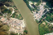
Visor del Estuario del Guadiana
Información elaborada por la Universidad de Sevilla en convenio con la Consejería de Medio Ambiente sobre el estuario del Río Guadiana. Información relativa al medio físico y a las actuaciones antrópicas sobre el ámbito transfronterizo de referencia, con el objetivo de servir de soporte a las tareas de planificación y gestión medioambiental en el área.
Simple
- Date (Creation)
- 2001-12-03
- Citation identifier
- Sin identificador
- Presentation form
- Digital map
- Purpose
-
Recopilación, levantamiento y difusión de información relativa al medio físico y a actuaciones antrópicas en el ámbito transfronterizo del Guadiana, para servir de soporte a las tareas de planificación y gestión medioambiental.
- Status
- Historical archive
- Point of contact
-
Organisation name Individual name Electronic mail address Role Consejería de Medio Ambiente. Junta de Andalucía
Owner
- Theme
-
-
informacion ambiental
-
edificios
-
municipios
-
pozos
-
hidrología
-
vegetación
-
recursos hídricos
-
recursos del suelo
-
-
GEMET - INSPIRE themes, version 1.0
-
-
Aspectos geográficos de carácter meteorológico
-
- Access constraints
- Other restrictions
- Use constraints
- Other restrictions
- Other constraints
-
Creative Commons Attribution 4.0 International Public License (CC BY 4.0)
- Spatial representation type
- Vector
- Language
- Spanish; Castilian
- Character set
- UTF8
- Topic category
-
- Farming
- Boundaries
- Environment
- Imagery base maps earth cover
- Location
))
- Supplemental Information
-
Inf_archivo/08_AMBITOS_INTERES_AMBIENTAL/02_LITORAL_MARINO/09_PRODUCTOS_DIFUSION_LITORAL/Informacion_Visor_Guadiana
- Reference system identifier
- EPSG:23030
- Reference system identifier
- INSPIRE RS registry / http://www.opengis.net/def/crs/EPSG/0/4258
- Distribution format
-
Name Version ESRI Shapefile
1.0
Layer
jpg
BMC
ECW
TIFF
- Units of distribution
-
Servicio WMS
- OnLine resource
-
Protocol Linkage Name OGC:WMS-1.3.0-http-get-map
http://www.juntadeandalucia.es/medioambiente/mapwms/REDIAM_guadiana_rutas REDIAM. WMS Rutas turísticas ámbito Guadiana
- Units of distribution
-
Servicio WMS
- OnLine resource
-
Protocol Linkage Name OGC:WMS-1.3.0-http-get-map
http://www.juntadeandalucia.es/medioambiente/mapwms/REDIAM_guadiana_limites REDIAM. WMS Límites administrativos
- Units of distribution
-
Servicio WMS
- OnLine resource
-
Protocol Linkage Name OGC:WMS-1.3.0-http-get-map
http://www.juntadeandalucia.es/medioambiente/mapwms/REDIAM_guadiana_unidades_fisiograficas REDIAM. WMS Unidades fisiograficas del entorno del estuario del Guadiana
- Units of distribution
-
Servicio WMS
- OnLine resource
-
Protocol Linkage Name OGC:WMS-1.3.0-http-get-map
http://www.juntadeandalucia.es/medioambiente/mapwms/REDIAM_guadiana_hidrologia REDIAM. WMS Red Hidrológica del entorno del estuario del Guadiana
- Units of distribution
-
Servicio WMS
- OnLine resource
-
Protocol Linkage Name OGC:WMS-1.3.0-http-get-map
http://www.juntadeandalucia.es/medioambiente/mapwms/REDIAM_guadiana_edificacion REDIAM. WMS Edificaciones del entorno del estuario del Guadiana
- Units of distribution
-
Servicio WMS
- OnLine resource
-
Protocol Linkage Name OGC:WMS-1.3.0-http-get-map
http://www.juntadeandalucia.es/medioambiente/mapwms/REDIAM_guadiana_carreteras REDIAM. WMS Vías de comunicación del entorno del estuario del Guadiana
- Units of distribution
-
Servicio WMS
- OnLine resource
-
Protocol Linkage Name OGC:WMS-1.3.0-http-get-map
http://www.juntadeandalucia.es/medioambiente/mapwms/REDIAM_guadiana_usos_suelo REDIAM. WMS Usos del suelo del entorno de estuario del Guadiana
- Units of distribution
-
Servicio WMS
- OnLine resource
-
Protocol Linkage Name OGC:WMS-1.3.0-http-get-map
http://www.juntadeandalucia.es/medioambiente/mapwms/REDIAM_Ortofoto_Guadiana_InterregII_2000? REDIAM. WMS Ortofoto de la Desembocadura del Río Guadiana (Algarve-Andalucía) color (RGB) de 2000
- Units of distribution
-
DVD en descarga
- OnLine resource
-
Protocol Linkage Name WWW:LINK-1.0-http--related
http://www.juntadeandalucia.es/medioambiente/servtorrent/Guia_interactiva_Estuario_Guadiana.iso.torrent Guía Interactiva del Estuario del Guadiana. DVD, 2001
- Units of distribution
-
Ficha WMS
- OnLine resource
-
Protocol Linkage Name WWW:LINK-1.0-http--related
http://www.juntadeandalucia.es/medioambiente/site/rediam/menuitem.04dc44281e5d53cf8ca78ca731525ea0/?vgnextoid=809c30945ae08310VgnVCM2000000624e50aRCRD&vgnextchannel=a26e854828158310VgnVCM2000000624e50aRCRD&vgnextfmt=rediam&lr=lang_es Ficha WMS Mapa de Edificaciones en el entorno del estuario del Guadiana
- Units of distribution
-
Ficha WMS
- OnLine resource
-
Protocol Linkage Name WWW:LINK-1.0-http--related
http://www.juntadeandalucia.es/medioambiente/site/rediam/menuitem.04dc44281e5d53cf8ca78ca731525ea0/?vgnextoid=202e30945ae08310VgnVCM2000000624e50aRCRD&vgnextchannel=a26e854828158310VgnVCM2000000624e50aRCRD&vgnextfmt=rediam&lr=lang_es Ficha WMS Mapa de la Red Hidrológica en el entorno del estuario del Guadiana
- Units of distribution
-
Ficha WMS
- OnLine resource
-
Protocol Linkage Name WWW:LINK-1.0-http--related
http://www.juntadeandalucia.es/medioambiente/site/rediam/menuitem.04dc44281e5d53cf8ca78ca731525ea0/?vgnextoid=f55a30945ae08310VgnVCM2000000624e50aRCRD&vgnextchannel=a26e854828158310VgnVCM2000000624e50aRCRD&vgnextfmt=rediam&lr=lang_es Ficha WMS Mapa de Vías de comunicación en el entorno del estuario del Guadiana
- Units of distribution
-
Ficha WMS
- OnLine resource
-
Protocol Linkage Name WWW:LINK-1.0-http--related
http://www.juntadeandalucia.es/medioambiente/site/rediam/menuitem.04dc44281e5d53cf8ca78ca731525ea0/?vgnextoid=e4e1eafbd8e08310VgnVCM1000001325e50aRCRD&vgnextchannel=a26e854828158310VgnVCM2000000624e50aRCRD&vgnextfmt=rediam&lr=lang_es Ficha WMS Rutas turísticas en el ámbito del estuario del Guadiana
- Units of distribution
-
Ficha WMS
- OnLine resource
-
Protocol Linkage Name WWW:LINK-1.0-http--related
http://www.juntadeandalucia.es/medioambiente/site/rediam/menuitem.04dc44281e5d53cf8ca78ca731525ea0/?vgnextoid=bf10eafbd8e08310VgnVCM1000001325e50aRCRD&vgnextchannel=a26e854828158310VgnVCM2000000624e50aRCRD&vgnextfmt=rediam&lr=lang_es Ficha WMS Límites administrativos en el entorno del estuario del Guadiana
- Units of distribution
-
Ficha WMS
- OnLine resource
-
Protocol Linkage Name WWW:LINK-1.0-http--related
http://www.juntadeandalucia.es/medioambiente/site/rediam/menuitem.04dc44281e5d53cf8ca78ca731525ea0/?vgnextoid=a9af37f681c08310VgnVCM1000001325e50aRCRD&vgnextchannel=a26e854828158310VgnVCM2000000624e50aRCRD&vgnextfmt=rediam&lr=lang_es Ficha WMS Mapa de Usos del suelo en torno al estuario del Guadiana
- Units of distribution
-
Ficha WMS
- OnLine resource
-
Protocol Linkage Name WWW:LINK-1.0-http--related
http://www.juntadeandalucia.es/medioambiente/site/rediam/menuitem.04dc44281e5d53cf8ca78ca731525ea0/?vgnextoid=aa0f30945ae08310VgnVCM2000000624e50aRCRD&vgnextchannel=a26e854828158310VgnVCM2000000624e50aRCRD&vgnextfmt=rediam&lr=lang_es Ficha WMS Mapa de Unidades fisiograficas en el entorno del estuario del Guadiana
- Units of distribution
-
Ficha WMS
- OnLine resource
-
Protocol Linkage Name WWW:LINK-1.0-http--related
http://www.juntadeandalucia.es/medioambiente/site/rediam/menuitem.04dc44281e5d53cf8ca78ca731525ea0/?vgnextoid=01a4826c494cf110VgnVCM1000001325e50aRCRD&vgnextchannel=90e122ad8470f210VgnVCM1000001325e50aRCRD&vgnextfmt=rediam&lr=lang_es Ficha WMS Ortofoto de la Desembocadura del Río Guadiana (Algarve-Andalucía) color (RGB) de 2000
- Units of distribution
-
Kml
- OnLine resource
-
Protocol Linkage Name OGC:KML
http://www.juntadeandalucia.es/medioambiente/portal_web/rediam/productos/ServiciosOGC/KML/Ortofotos/Locales/ortofoto_desemb_guadiana_interreg_2000.kml Fichero ortofoto_desemb_guadiana_interreg_2000.kml
- Units of distribution
-
Kml
- OnLine resource
-
Protocol Linkage Name OGC:KML
http://www.juntadeandalucia.es/medioambiente/portal_web/rediam/productos/ServiciosOGC/KML/Cartografia_ambiental/Ambitos_interes_ambiental/unidades_fisiograficas_guadiana.kml Fichero unidades_fisiograficas_guadiana.kml
- Units of distribution
-
Kml
- OnLine resource
-
Protocol Linkage Name OGC:KML
http://www.juntadeandalucia.es/medioambiente/portal_web/rediam/productos/ServiciosOGC/KML/Cartografia_ambiental/Ambitos_interes_ambiental/usos_suelo_guadiana.kml Fichero usos_suelo_guadiana.kml
- Units of distribution
-
Kml
- OnLine resource
-
Protocol Linkage Name OGC:KML
http://www.juntadeandalucia.es/medioambiente/portal_web/rediam/productos/ServiciosOGC/KML/Cartografia_ambiental/Ambitos_interes_ambiental/limites_administrativos_guadiana.kml Fichero limites_administrativos_guadiana.kml
- Units of distribution
-
Kml
- OnLine resource
-
Protocol Linkage Name OGC:KML
http://www.juntadeandalucia.es/medioambiente/portal_web/rediam/productos/ServiciosOGC/KML/Cartografia_ambiental/Ambitos_interes_ambiental/rutas_turisticas_guadiana.kml Fichero rutas_turisticas_guadiana.kml
- Units of distribution
-
Kml
- OnLine resource
-
Protocol Linkage Name OGC:KML
http://www.juntadeandalucia.es/medioambiente/portal_web/rediam/productos/ServiciosOGC/KML/Cartografia_ambiental/Ambitos_interes_ambiental/vias_comunicacion_guadiana.kml Fichero vias_comunicacion_guadiana.kml
- Units of distribution
-
Kml
- OnLine resource
-
Protocol Linkage Name OGC:KML
http://www.juntadeandalucia.es/medioambiente/portal_web/rediam/productos/ServiciosOGC/KML/Cartografia_ambiental/Ambitos_interes_ambiental/hidrologia_guadiana.kml Fichero hidrologia_guadiana.kml
- Units of distribution
-
Kml
- OnLine resource
-
Protocol Linkage Name OGC:KML
http://www.juntadeandalucia.es/medioambiente/portal_web/rediam/productos/ServiciosOGC/KML/Cartografia_ambiental/Ambitos_interes_ambiental/edificaciones_guadiana.kml Fichero edificaciones_guadiana.kml
- Units of distribution
-
Datos en descarga
- Transfer size
- 1100
- OnLine resource
-
Protocol Linkage Name WWW:LINK-1.0-http--related
https://portalrediam.cica.es/descargas?path=%2FInf_archivo%2F08_AMBITOS_INTERES_AMBIENTAL%2F02_LITORAL_MARINO%2F09_PRODUCTOS_DIFUSION_LITORAL%2FInformacion_Visor_Guadiana Descarga Visor del Estuario del Guadiana (Informacion_Visor_Guadiana)
- Hierarchy level
- Dataset
Conformance result
- Date (Publication)
- 2010-12-08
Citation identifier
- Explanation
-
Consultar el reglamento mencionado
- Pass
- Yes
- Description
-
Recepción de la información
Normalización de la información
Integración en REDIAM
- Date / Time
- 2011-06-09T00:00:00
- File identifier
- 76410606-2ff7-4140-a28a-4abe20b41e3c XML
- Metadata language
- Spanish; Castilian
- Character set
- UTF8
- Hierarchy level
- Dataset
- Date stamp
- 2024-11-25T13:31:21.038Z
- Metadata standard name
-
ISO 19115 "NEM"
- Metadata standard version
-
2003 "1.0"
- Metadata author
-
Organisation name Individual name Electronic mail address Role Consejería de Sostenibilidad y Medio Ambiente. Junta de Andalucía
Author
Overviews
Spatial extent
Provided by
