 Catálogo REDIAM
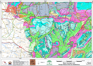
Mapa geológico del Geoparque Sierras Subbéticas. Córdoba
Mapa de síntesis de la cartografía geológica a escala 1:50.000 del Instituto Geológico y Minero de España (IGME). El mapa en formato PDF ha sido elaborado por Tragsatec por encargo de la Consejería de Medio Ambiente para la divulgación de la geología del Parque Natural de Sierras Subbéticas. Dicho Parque Natural pertenece desde 2006 a las Redes Europea y Mundial de Geoparques, avaladas por la UNESCO.
Simple
- Date (Creation)
- 2011-12-01
- Citation identifier
- Sin identificador
- Presentation form
- Digital document
- Purpose
-
Divulgar la geología del Geoparque "Sierras Subbéticas".
- Status
- Completed
- Point of contact
-
Organisation name Individual name Electronic mail address Role Consejería de Medio Ambiente y Ordenación del Territorio. Junta de Andalucía
Owner
- Theme
-
-
cartografía
-
geología
-
mapas
-
espacios protegidos
-
-
GEMET - INSPIRE themes, version 1.0
-
-
Geología
-
-
Registro de temas REDIAM
-
-
Geodiversidad
-
- Access constraints
- Other restrictions
- Use constraints
- Other restrictions
- Other constraints
-
Creative Commons Attribution 4.0 International Public License (CC BY 4.0)
- Spatial representation type
- Language
- Spanish; Castilian
- Character set
- UTF8
- Topic category
-
- Environment
- Geoscientific information
- Location
))
- Supplemental Information
-
\04_RECURSOS_NATURALES\02_GEODIVERSIDAD\06_PRODUCTOS_DIFUSION_GEODIVERSIDAD\MapaGeologico_SSubbeticas
Reference System Information
- Unique resource identifier
- EPSG:25830
- Distribution format
-
Name Version PDF
ESRI Shapefile
1.0
- Units of distribution
-
Publicación web
- OnLine resource
-
Protocol Linkage Name WWW:LINK-1.0-http--related
https://www.juntadeandalucia.es/medioambiente/portal/landing-page-%C3%ADndice/-/asset_publisher/zX2ouZa4r1Rf/content/geoparque-sierras-subb-c3-a9ticas/20151 Apartado web de la Consejería sobre el "Geoparque Mundial de la Unesco Sierras Subbéticas"
- Units of distribution
-
Datos en descarga
- OnLine resource
-
Protocol Linkage Name WWW:LINK-1.0-http--related
https://descargasrediam.cica.es/repo/s/RUR?path=%2F04_RECURSOS_NATURALES%2F02_GEODIVERSIDAD%2F06_PRODUCTOS_DIFUSION_GEODIVERSIDAD%2FMapaGeologico_SSubbeticas Descarga Mapa geológico del Geoparque Sierras Subbéticas. Córdoba (MapaGeologico_SSubbeticas)
- Hierarchy level
- Dataset
Conformance result
- Date (Publication)
- 2010-12-08
Citation identifier
- Explanation
-
Consultar el reglamento mencionado
- Pass
- Yes
- Description
-
La sintesis de la cartografía geológica del IGME a escala 1:50.000 la ha realizado la empresa "Ador Consultoría, S.L." en 2009.
La revisión y composición del mapa la ha realizado Tragsatec en 2011. La escala de impresión en papel del mapa en tamaño DIN-A3 es 1:45.000.
Desde la Rediam se ha elaborado un modelo de datos, el cual ha sido revisado por Alberto Gil (Tragsatec).
- Date / Time
- 2009-01-01T00:00:00
- Description
-
Geología: Mapa Geológico Nacional a escala 1:50.000, Instituto Geológico y Minero de España, 2011. Altimetría y Planimetría: Mapa Topográfico de Andalucía 1:10.000, Junta de Andalucía.
- File identifier
- 892f9c9c-c592-4dfe-bdbd-0f6ddbd9f58f XML
- Metadata language
- Spanish; Castilian
- Character set
- UTF8
- Hierarchy level
- Dataset
- Date stamp
- 2025-03-14T14:58:27.887Z
- Metadata standard name
-
ISO 19115 "NEM"
- Metadata standard version
-
2003 "1.0"
- Metadata author
-
Organisation name Individual name Electronic mail address Role Consejería de Sostenibilidad y Medio Ambiente. Junta de Andalucía
Author
Overviews
Spatial extent
Provided by
