 Catálogo REDIAM
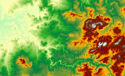
MDE Ámbito de la Costa de Granada, 2006
Modelo Digital de Elevaciones: Superficie (MDS) del ámbito de la Costa de Granada generado a partir de vuelo Lidar (1m) de 2006. (V164_el).
Simple
- Date (Creation)
- 2008-02-23
- Date (Revision)
- 2009-03-01
- Presentation form
- Digital model
- Purpose
-
Base de Cartográfica de Referencia Altimétrica y obtención un modelo a nivel del suelo a partir del cual se obtengan unas ortofotos correctas geométricamente.
- Status
- Historical archive
- Point of contact
-
Organisation name Individual name Electronic mail address Role Agencia Andaluza del Agua (AAA). Consejería de Medio Ambiente. Junta de Andalucía
Author
-
Observación del Territorio
-
-
Observación del Territorio. Producto primario
-
- Theme
-
-
Fotografía aérea
-
Fotogrametría
-
IDEAndalucia
-
Opendata
-
-
GEMET - INSPIRE themes, version 1.0
-
-
Elevaciones
-
-
Registro de temas REDIAM
-
-
Teledetección y caracterización del territorio
-
- Access constraints
- Other restrictions
- Use constraints
- Other restrictions
- Other constraints
-
Creative Commons Attribution 4.0 International Public License (CC BY 4.0)
- Spatial representation type
- Grid
- Language
- Spanish; Castilian
- Character set
- UTF8
- Topic category
-
- Elevation
))
- Supplemental Information
-
01070102
- Reference system identifier
- EPSG:25830
- Reference system identifier
- INSPIRE RS registry / http://www.opengis.net/def/crs/EPSG/0/4258
- Distribution format
-
Name Version TIFF
ASCIIXYZ
- Units of distribution
-
Datos en descarga
- OnLine resource
-
Protocol Linkage Name WWW:LINK-1.0-http--link
https://portalrediam.cica.es/descargas?path=%2F01_CARACTERIZACION_TERRITORIO%2F07_BASES_REF_ELEV%2F01_ELEVACIONES%2F02_PROYECTOS_LOCALES%2F2006_06_07_GR_Litoral_Granada_V164_el Descarga MDE Ámbito de la Costa de Granada, 2006
- Hierarchy level
- Dataset
Conformance result
- Date (Publication)
- 2010-12-08
Citation identifier
- Explanation
-
Consultar el reglamento mencionado
- Pass
- Yes
- Statement
-
Para generar el modelo digital de elevaciones se parte del vuelo fotogramétrico con la información GPS e IMU, el apoyo y la aerotriangulación.
- Description
-
Generado a partir del vuelo fotogramétrico esclavo (digital + lidar) de 1m de resolución de la Consejería de Medio Ambiente.
- File identifier
- 8c6ff6b8-04d5-43bd-81fa-43cc7152557e XML
- Metadata language
- Spanish; Castilian
- Character set
- UTF8
- Hierarchy level
- Dataset
- Date stamp
- 2022-10-20T09:02:32
- Metadata standard name
-
ISO 19115 "NEM"
- Metadata standard version
-
2003 "1.0"
- Metadata author
-
Organisation name Individual name Electronic mail address Role Consejería de Sostenibilidad, Medio Ambiente y Economía Azul. Junta de Andalucía
Author
Overviews

Spatial extent
Provided by
