 Catálogo REDIAM
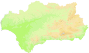
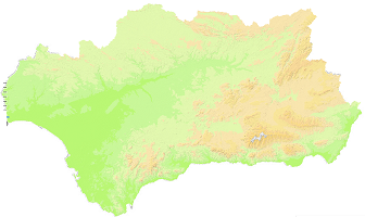
Mapa Hipsométrico de Andalucía, 2010 (20x20m)
Mapa hipsométrico para representar el relieve, a escala 1:50.000. Elaborado a partir del MDT de 20 metros (generado a su vez a partir del MDT de 10 m elaborado para la Ortofotografía Digital de Andalucía de los años 2001-2002).
Simple
- Date (Creation)
- 2010-09-30
- Citation identifier
- Sin identificador
- Presentation form
- Digital image
- Purpose
-
Servir de fondo para la elaboración de cartografía 1:50.000
- Status
- Completed
- Point of contact
-
Organisation name Individual name Electronic mail address Role Consejería de Medio Ambiente y Ordenación del Territorio. Junta de Andalucía
Author
- Theme
-
-
mapas
-
relieve
-
IDEAndalucia
-
-
GEMET - INSPIRE themes, version 1.0
-
-
Elevaciones
-
- Access constraints
- Other restrictions
- Use constraints
- Other restrictions
- Other constraints
-
Creative Commons Attribution 4.0 International Public License (CC BY 4.0)
- Spatial representation type
- Grid
- Language
- Spanish; Castilian
- Character set
- UTF8
- Topic category
-
- Elevation
- Imagery base maps earth cover
))
- Supplemental Information
-
0101
- Reference system identifier
- EPSG:23030
- Reference system identifier
- INSPIRE RS registry / http://www.opengis.net/def/crs/EPSG/0/4258
- Distribution format
-
Name Version JP2
- Units of distribution
-
Servicio WMS
- OnLine resource
-
Protocol Linkage Name OGC:WMS-1.3.0-http-get-map
http://www.juntadeandalucia.es/medioambiente/mapwms/REDIAM_mapa_hipsometrico_50000 REDIAM. WMS Mapa hipsométrico de 20 metros de resolución a escala 1:50.000 del año 2010. Consejería de Agricultura, Pesca y Medio Ambiente, Junta de Andalucía
- Units of distribution
-
Ficha WMS
- OnLine resource
-
Protocol Linkage Name WWW:LINK-1.0-http--related
http://www.juntadeandalucia.es/medioambiente/site/rediam/menuitem.04dc44281e5d53cf8ca78ca731525ea0/?vgnextoid=008b99fe3211d310VgnVCM1000001325e50aRCRD&vgnextchannel=33be7c119370f210VgnVCM2000000624e50aRCRD&vgnextfmt=rediam&lr=lang_es Ficha WMS Mapa hipsométrico de Andalucía de 20 metros de resolución a escala 1:50.000. Año 2010
- Units of distribution
-
Kml
- OnLine resource
-
Protocol Linkage Name WWW:LINK-1.0-http--related
http://www.juntadeandalucia.es/medioambiente/portal_web/rediam/productos/ServiciosOGC/KML/Cartografia_ambiental/Localizacion_geografica/mapa_hipsometrico_50000.kml Ficha mapa_hipsometrico_50000.kml
- Units of distribution
-
Datos en descarga
- OnLine resource
-
Protocol Linkage Name WWW:LINK-1.0-http--related
https://descargasrediam.cica.es/repo/s/RUR?path=%2F01_CARACTERIZACION_TERRITORIO%2F01_BASES_REF_TOPOGRAFICAS%2FMapa_Hipsometrico_50000 Descarga Mapa hipsométrico de Andalucía a escala 20 mts (Mapa_Hipsometrico_50000)
- Hierarchy level
- Dataset
Conformance result
- Date (Publication)
- 2010-12-08
Citation identifier
- Explanation
-
Consultar el reglamento mencionado
- Pass
- Yes
- Description
-
Clasificación de los valores del MDT de 20 m en función de los rangos de cota
Ajuste del histograma para generar el color de fondo en función de la altitud
Ajuste del histograma del modelo de sombras del MDT20
Ajuste del histograma, brillo y contraste del hipsométrico obtenido
- Date / Time
- 2010-06-07T00:00:00
- File identifier
- 9d0ea44e-d8be-4833-9df2-d1313c7b6421 XML
- Metadata language
- Spanish; Castilian
- Character set
- UTF8
- Hierarchy level
- Dataset
- Date stamp
- 2022-09-22T09:35:36
- Metadata standard name
-
ISO 19115 "NEM"
- Metadata standard version
-
2003 "1.0"
- Metadata author
-
Organisation name Individual name Electronic mail address Role Consejería de Sostenibilidad y Medio Ambiente. Junta de Andalucía
Author
Overviews
Spatial extent
Provided by
