 Catálogo REDIAM
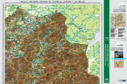
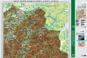
Base cartográfica del mapa guía del Parque Natural Sierra de Cazorla, Segura y Las Villas del año 2012
Georreferenciación del Mapa Guía Parque Natural Sierra de Cazorla, Segura y Las Villas del año 2012.
Simple
- Date (Creation)
- 2014-05-02
- Citation identifier
- Sin identificador
- Presentation form
- Digital image
- Purpose
-
Base de referencia
- Status
- Completed
- Point of contact
-
Organisation name Individual name Electronic mail address Role Consejería de Medio Ambiente y ordenación del Territorio. Junta de Andalucía
Author
- Theme
-
-
sendero
-
mapa
-
cartografía
-
espacio natural
-
uso público
-
IDEAndalucia
-
-
GEMET - INSPIRE themes, version 1.0
-
-
Lugares protegidos
-
- Use limitation
-
Derechos de propiedad intelectual.
- Access constraints
- Intellectual property rights
- Use constraints
- Intellectual property rights
- Spatial representation type
- Grid
- Language
- Spanish; Castilian
- Character set
- UTF8
- Topic category
-
- Boundaries
- Environment
- Imagery base maps earth cover
))
- Supplemental Information
-
0701010901
- Reference system identifier
- EPSG:25830
- Reference system identifier
- INSPIRE RS registry / http://www.opengis.net/def/crs/EPSG/0/4258
- Distribution format
-
Name Version TIFF
lyr
pdf
- Units of distribution
-
Servicio WMS
- OnLine resource
-
Protocol Linkage Name OGC:WMS-1.3.0-http-get-map
http://www.juntadeandalucia.es/medioambiente/mapwms/REDIAM_mapa_guia_pn_sierra_cazorla_2012? REDIAM. WMS Base cartográfica del mapa guía del Parque Natural Sierras de Cazorla, Segura y Las Villas del año 2012
- Units of distribution
-
Ficha WMS
- OnLine resource
-
Protocol Linkage Name WWW:LINK-1.0-http--related
http://www.juntadeandalucia.es/medioambiente/site/rediam/menuitem.04dc44281e5d53cf8ca78ca731525ea0/?vgnextoid=e543ccee7450f410VgnVCM2000000624e50aRCRD&vgnextchannel=f17a54fdca04f410VgnVCM2000000624e50aRCRD&vgnextfmt=rediam&lr=lang_es Ficha WMS Base cartográfica del mapa guía del Parque Natural Sierras de Cazorla, Segura y Las Villas del año 2012
- Units of distribution
-
Datos en descarga
- OnLine resource
-
Protocol Linkage Name WWW:LINK-1.0-http--related
http://descargasrediam.cica.es/repo/s/RUR?path=%2F07_PATRIMONIO_NATURAL%2F01_ESPACIOS_PROTEGIDOS%2F01_RENPA%2F09_GUIAS%2F01_MAPAS_GUIA%2FMG_Cazorla_2012 Descarga Base cartográfica del mapa guía del Parque Natural Sierra de Cazorla, Segura y Las Villas del año 2012 (MG_Cazorla_2012)
- Hierarchy level
- Dataset
Conformance result
- Date (Publication)
- 2010-12-08
Citation identifier
- Explanation
-
Consultar el reglamento mencionado
- Pass
- Yes
- Statement
-
Mapa Guía Parque Natural Sierra de Cazorla, Segura y Las Villas. 2012
- Description
-
Georreferenciación del mapa rasterizado utilizando la herramienta de ArcMap, Georreferencing. Transformación afín, de 1º orden.
- Date / Time
- 2014-05-02T00:00:00
- Description
-
Consejería de Medio Ambiente y Ordenación del Territorio. Junta de Andalucía.
- File identifier
- a16f774e-3291-4c04-8b99-a04c5827fd22 XML
- Metadata language
- Spanish; Castilian
- Character set
- UTF8
- Hierarchy level
- Dataset
- Date stamp
- 2022-09-01T10:00:51
- Metadata standard name
-
ISO 19115 "NEM"
- Metadata standard version
-
2003 "1.0"
- Metadata author
-
Organisation name Individual name Electronic mail address Role Consejería de Sostenibilidad y Medio Ambiente. Junta de Andalucía
Author
Overviews
Spatial extent
Provided by
