 Catálogo REDIAM
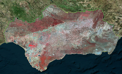
Ortofotografía Andalucía 2020-21
Ortofoto regional de Andalucía con resolución 0.25 m generada por el Instituto Geográfico Nacional (IGN) y la Junta de Andalucía (JA) a partir del vuelo fotogramétrico-LIDAR realizado en el marco del Plan Nacional de Ortofotografía Aérea (PNOA).
Disponible en 1 coleccion RGBIr con resolución de 0.25m. (V226_of).
Simple
- Date (Creation)
- 2020-11-17
- Presentation form
- Digital image
- Purpose
-
Disponibilidad de Bases de referencia cartográfica planimétrica.
- Status
- Completed
- Point of contact
-
Organisation name Individual name Electronic mail address Role Instituto Geográfico Nacional (IGN)
Owner Consejería de Sostenibilidad, Medio Ambiente y Economía Azul. Junta de Andalucía
Owner
-
Observación del Territorio
-
-
Observación del Territorio. Producto primario
-
- Keywords
-
-
Fotografía Aérea
-
Fotogrametría
-
Opendata
-
IDEAndalucia
-
Andalucía
-
REDIAM
-
-
GEMET - INSPIRE themes, version 1.0
-
-
Ortoimágenes
-
-
Registro de temas REDIAM
-
-
Teledetección y caracterización del territorio
-
-
GEMET - INSPIRE themes, version 1.0
-
-
Ortoimágenes
-
- Access constraints
- Other restrictions
- Use constraints
- Other restrictions
- Other constraints
-
Creative Commons Attribution 4.0 International Public License (CC BY 4.0)
- Spatial representation type
- Grid
- Language
- Spanish; Castilian
- Character set
- UTF8
- Topic category
-
- Imagery base maps earth cover
))
- Supplemental Information
-
\01_CARACTERIZACION_TERRITORIO\02_BASES_REF_ORTOFOTOS_ORTOIMAGENES\01_ORTOFOTOS\01_PROYECTOS_REGIONALES\2020_AND_0.25m_V226_of
- Reference system identifier
- EPSG:3042
- Reference system identifier
- INSPIRE RS registry / http://www.opengis.net/def/crs/EPSG/0/3042
- Distribution format
-
Name Version ECW
JPEG2000
- Units of distribution
-
Servicio WMS
- OnLine resource
-
Protocol Linkage Name OGC:WMS-1.3.0-http-get-map
https://www.juntadeandalucia.es/medioambiente/mapwms/REDIAM_Ortofoto_2020? REDIAM. WMS Ortofoto Digital de Andalucía año 2020
- Units of distribution
-
Publicación Web
- OnLine resource
-
Protocol Linkage Name WWW:LINK-1.0-http--related
https://www.juntadeandalucia.es/medioambiente/portal/web/guest/landing-page-servicio-ogc/-/asset_publisher/1qlWV3LW9vV6/content/rediam.-wms-ortofoto-digital-de-andaluc-c3-ada-a-c3-b1o-2020/20151 Ficha Web del WMS Ortofoto Digital de Andalucía año 2020
- Units of distribution
-
Datos en descarga
- OnLine resource
-
Protocol Linkage Name WWW:LINK-1.0-http--related
https://portalrediam.cica.es/descargas?path=%2F01_CARACTERIZACION_TERRITORIO%2F02_BASES_REF_ORTOFOTOS_ORTOIMAGENES%2F01_ORTOFOTOS%2F01_PROYECTOS_REGIONALES%2F2020_AND_0.25m_V226_of Descarga de a Ortofotografía digital RGBlr con resolución de 0.25m,generada por el Instituto Geográfico Nacional (IGN) y la Junta de Andalucía (JA)
- Hierarchy level
- Dataset
Conformance result
- Date (Publication)
- 2010-12-08
Citation identifier
- Explanation
-
Consultar el reglamento mencionado
- Pass
- Yes
- Statement
-
Proceso Fotogramétrico digital PNOA con verificación de controles de calidad de fases y productos (establecidos por PNOA), establecidos por organismos productores y propietarios. Desde la Rediam, realizada revisión de productos recibidos de todo el proceso fotogramétrico, normalización según criterios Rediam y obtención del producto en formato interoperable.
- Description
-
1º. Proceso de Producción de Ortofotografía Básica según prescripciones, productos y controles de calidad PNOA. Desarrolladas las fases de Apoyo de Campo (AC), Aerotriangulación (AT), Modelo de Elevaciones (EL) y Ortorectificación (OF) para obtener un producto de 4 bandas.
- Date / Time
- Invalid DateT00:00:00
- Description
-
El cuadrante Noroeste de Andalucía se ha elaborado a 50 cm de resolución. Se parte de un vuelo digital de 0.45 metros de resolución geométrica, con información en RGB, infrarrojo y pancromático realizado en la verano del año 2011, con las cámaras métricas DMC14 y DMC16 con cobertura estereoscópica de toda la zona de trabajo.
- File identifier
- a9c4fb61-4b5a-4762-9cf0-3ae01539cb9a XML
- Metadata language
- Spanish; Castilian
- Character set
- UTF8
- Hierarchy level
- Dataset
- Date stamp
- 2024-02-21T06:40:33.848Z
- Metadata standard name
-
ISO 19115 "NEM"
- Metadata standard version
-
2003 "1.0"
- Metadata author
-
Organisation name Individual name Electronic mail address Role Consejería de Sostenibilidad, Medio Ambiente y Economía Azul. Junta de Andalucía
Author
Overviews
Spatial extent
Provided by
