 Catálogo REDIAM
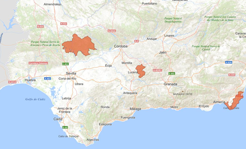
Geoparques de Andalucía, septiembre de 2011
Capa actualizada de los Geoparques en Andalucía. Declarados por la UNESCO, representan un territorio que posee una riqueza geológica particular y una estrategia de desarrollo territorial sostenible apoyada por un programa europeo para promocionar el desarrollo. Andalucía cuenta con tres Geoparques: Parque Natural Cabo de Gata-Níjar (junio de 2001), Parque Natural de las Sierras Subbéticas (julio 2006) y Parque Natural Sierra Norte (septiembre de 2011). Existe otro Geoparque en Andalucía, el Geoparque de Granada, designado durante la reunión del Consejo Ejecutivo de Geoparques UNESCO celebrada en julio de 2020. Este Geoparque ha sido impulsado por la Diputación de Granada junto a los municipios que lo integran, quienes además constituyen su órgano de gestión. El papel de la Consejería competente en medio ambiente para esta candidatura se limitó a una carta de apoyo a su candidatura así como reuniones técnicas de asesoramiento. Más información en su web, https://www.geoparquedegranada.com/
Simple
- Date (Revision)
- 2011-10-31
- Date (Creation)
- 2001-01-01
- Presentation form
- Digital document
- Purpose
-
Conocer el ámbito geográfico protegido en Andalucía por la figura de protección Geoparque.
- Status
- Completed
- Point of contact
-
Organisation name Individual name Electronic mail address Role Consejería de Sostenibilidad y Medio Ambiente. Junta de Andalucía
Author
-
Registro de temas REDIAM
-
-
Espacios Protegidos
-
- Theme
-
-
Geología
-
Geoparque
-
Área natural sensible
-
Parques naturales
-
IDEAndalucia
-
datosabiertosJA
-
-
GEMET - INSPIRE themes, version 1.0
-
-
Lugares protegidos
-
-
Ámbito espacial
-
-
Regionales
-
-
High-value dataset categories
-
-
Observación de la Tierra y medio ambiente
-
- Keywords
- Access constraints
- Other restrictions
- Use constraints
- Other restrictions
- Other constraints
-
Creative Commons Attribution 4.0 International Public License (CC BY 4.0)
- Spatial representation type
- Vector
- Denominator
- 10000
- Language
- Spanish; Castilian
- Character set
- UTF8
- Topic category
-
- Biota
- Environment
))
- Supplemental Information
-
\07_PATRIMONIO_NATURAL\01_ESPACIOS_PROTEGIDOS\01_RENPA\06_GEOPARQUES\Geoparques_2011_09
- Reference system identifier
- EPSG:3042
- Reference system identifier
- INSPIRE RS registry / http://www.opengis.net/def/crs/EPSG/0/3042
- Reference system identifier
- EPSG:3042
- Reference system identifier
- INSPIRE RS registry / http://www.opengis.net/def/crs/EPSG/0/3042
- Distribution format
-
Name Version Geopackage
ESRI Shapefile
1.0
WMS
1.3.0
WFS
1.1.0
- Units of distribution
-
Datos en descarga
- OnLine resource
-
Protocol Linkage Name https://portalrediam.cica.es/descargas?path=%2F07_PATRIMONIO_NATURAL%2F01_ESPACIOS_PROTEGIDOS%2F01_RENPA%2F06_GEOPARQUES%2FGeoparques_2011_09 Descarga capa de Geoparques de Andalucía (Geoparques_2011_09)
- Units of distribution
-
Aplicación Web
- OnLine resource
-
Protocol Linkage Name https://portalrediam.cica.es/VisorRediam/ Visualizador de Servicios OGC de la REDIAM
- Units of distribution
-
Publicación Web
- OnLine resource
-
Protocol Linkage Name WWW:LINK-1.0-http--related
https://www.juntadeandalucia.es/medioambiente/portal/web/ventanadelvisitante/espacios-naturales Ventana del Visitante de Espacios Naturales de Andalucía
- Units of distribution
-
Publicación Web
- OnLine resource
-
Protocol Linkage Name WWW:LINK-1.0-http--related
https://www.juntadeandalucia.es/medioambiente/portal/web/guest/areas-tematicas/espacios-protegidos/otros-espacios-protegidos-caracter-internacional/geoparques Geoparques de Andalucía
- Units of distribution
-
Servicio WMS
- OnLine resource
-
Protocol Linkage Name OGC:WMS-1.3.0-http-get-map
https://www.juntadeandalucia.es/medioambiente/mapwms/REDIAM_GeoParques?. REDIAM. WMS Geoparques de Andalucía, septiembre de 2011
- Units of distribution
-
Servicio WMS
- OnLine resource
-
Protocol Linkage Name OGC:WMS-1.3.0-http-get-map
https://www.juntadeandalucia.es/medioambiente/mapwms/REDIAM_RENPA? WMS Red de Espacios Naturales Protegidos de Andalucía (RENPA)
- Units of distribution
-
Servicio WFS
- OnLine resource
-
Protocol Linkage Name OGC:WFS
https://www.juntadeandalucia.es/medioambiente/mapwms/REDIAM_GeoParques?. REDIAM. WFS Geoparques de Andalucía, septiembre de 2011
- Units of distribution
-
Ficha Canal REDIAM
- OnLine resource
-
Protocol Linkage Name WWW:LINK-1.0-http--link
https://www.juntadeandalucia.es/medioambiente/portal/landing-page-servicio-ogc/-/asset_publisher/1qlWV3LW9vV6/content/rediam.-wms-geoparques-de-andaluc-c3-ada-septiembre-de-2011/20151 REDIAM. WMS-WFS Geoparques de Andalucía septiembre de 2011
- Hierarchy level
- Dataset
Conformance result
- Date (Publication)
- 2011-08-31
Citation identifier
- Explanation
-
Consultar el reglamento mencionado
- Pass
- Yes
- Statement
-
1º Selección de la base de referencia para el levantamiento de información. 2º Captura de información siguiendo los criterios de digitalización establecidos por parte del centro directivo competente. Elaboración del modelo de datos. 3º Remisión de datos al Servicio de Información y Evaluación Ambiental para su integración en la Red de Información Ambiental de Andalucía (REDIAM). 4º Integración de datos, control de calidad y validación. Comprobación de la estructura del contenido. Comprobación de la consistencia topológica. 5º Validación por el Servicio de Coordinación y Gestión de la RENPA 6º Publicación de ficha de metadatos en el Catálogo de la REDIAM. 7º Difusión de la información a través de Servicios OGC y descarga de la misma.
- Description
-
Las distintas normativas que aprueban, amplían o ajustan la delimitación de los EENNPP
- File identifier
- af0f97b5-7e94-4a85-bc0f-15f3a651c60b XML
- Metadata language
- Spanish; Castilian
- Character set
- UTF8
- Hierarchy level
- Dataset
- Date stamp
- 2025-10-27T07:05:27.707Z
- Metadata standard name
-
ISO 19115 "NEM"
- Metadata standard version
-
2003 "1.0"
- Metadata author
-
Organisation name Individual name Electronic mail address Role Consejería de Sostenibilidad y Medio Ambiente. Junta de Andalucía
Author
Overviews
Spatial extent
Provided by
