 Catálogo REDIAM
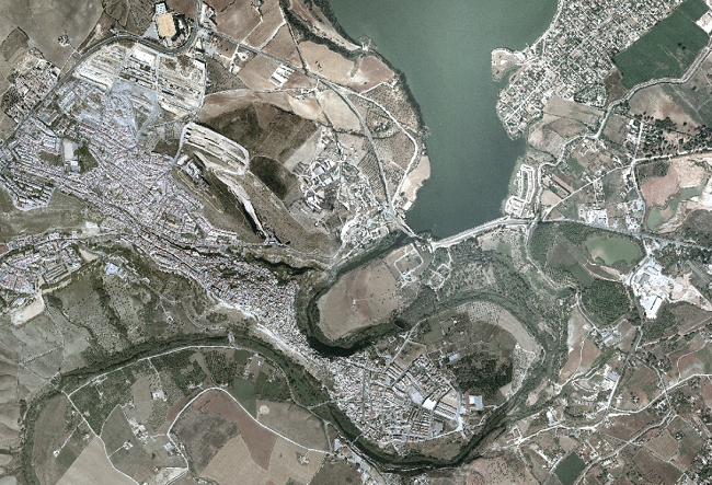
Ortofotografía Andalucía 2004-05
Composición cartográfica formada por los cuatro cuadrantes de Ortofografías de los años de vuelo de 2004 y 2005. Formada por: Ortofoto Infrarroja del Cuadrante Sureste (SE), Ortofoto Color del Cuadrante Suroeste (SW), ambas generadas a partir de distintos vuelos analógicos del año 2004, Ortofoto Infrarrojo del Cuadrante Noreste (NE) y Ortofoto Color del Cuadrante Noroeste (NW) de Andalucía ambas generadas a partir de distintos vuelos analógicos del año 2005, todos los cuadrantes de 0.5m de resolución.(V194_of)
Simple
- Date (Creation)
- 2012-05-10
- Presentation form
- Digital image
- Purpose
-
Disponibilidad de Base de Referencia Cartográfica en la Comunidad Autónoma de Andalucía
- Status
- Completed
- Point of contact
-
Organisation name Individual name Electronic mail address Role Consejería de Medio Ambiente. Junta de Andalucía
User
-
Observación del Territorio
-
-
Observación del Territorio. Producto primario
-
- Theme
-
-
Fotografía aérea
-
Fotogrametría
-
-
GEMET - INSPIRE themes, version 1.0
-
-
Ortoimágenes
-
- Use limitation
-
Para saber la licencia hay que mirar el campo de acceso y uso.
- Access constraints
- Other restrictions
- Use constraints
- Other restrictions
- Other constraints
-
Creative Commons Attribution 4.0 International Public License
- Spatial representation type
- Grid
- Language
- Spanish; Castilian
- Character set
- UTF8
- Topic category
-
- Imagery base maps earth cover
))
- Supplemental Information
-
01020101
- Reference system identifier
- EPSG:25830
- Reference system identifier
- INSPIRE RS registry / http://www.opengis.net/def/crs/EPSG/0/4258
- Distribution format
-
Name Version Shape
- Units of distribution
-
Servicio WMS
- OnLine resource
-
Protocol Linkage Name OGC:WMS-1.3.0-http-get-map
http://www.juntadeandalucia.es/medioambiente/mapwms/REDIAM_Ortofoto_Andalucia_2004_2005? WMS Ortofotografía Andalucía 2004-05
- Units of distribution
-
Datos en descarga
- OnLine resource
-
Protocol Linkage Name WWW:LINK-1.0-http--related
http://descargasrediam.cica.es/repo/s/RUR?path=%2F01_CARACTERIZACION_TERRITORIO%2F02_BASES_REF_ORTOFOTOS_ORTOIMAGENES%2F01_ORTOFOTOS%2F01_PROYECTOS_REGIONALES%2F2004_05_AND_0.5m_V194_of Descarga Ortofotografía Andalucía 2004-05 (2004_05_AND_0.5m_V194_of)
- Hierarchy level
- Series
Conformance result
- Date (Publication)
- 2010-12-08
Citation identifier
- Explanation
-
Consultar el reglamento mencionado
- Pass
- Yes
- Statement
-
Para generar la ortofotografía se utiliza la información proporcionada por el vuelo fotogramétrico, el apoyo de campo, la aerotriangulación y el modelo digital de elevaciones.
- Description
-
Vuelos fotogramétricos analógicos Color (SW-NW) e Infrarrojo (NE-SE) de los años 2005 y 2006.
- File identifier
- c0b7dbbb-4d48-4880-9436-ae7df6f0f1c3 XML
- Metadata language
- Spanish; Castilian
- Character set
- UTF8
- Hierarchy level
- Dataset
- Date stamp
- 2022-09-01T11:37:03
- Metadata standard name
-
ISO 19115 "NEM"
- Metadata standard version
-
2003 "1.0"
- Metadata author
-
Organisation name Individual name Electronic mail address Role Consejería de Sostenibilidad, Medio Ambiente y Economía Azul. Junta de Andalucía
Author
Overviews
Spatial extent
Provided by
