 Catálogo REDIAM
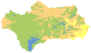
Mapa de Ombroclimas de Andalucía (SIPNA 2018), escala 1: 10.000
Distribución de los ombroclimas de Andalucía extraídos de la información de SIPNA (Sistema de Información del Patrimonio Natural de Andalucía) publicación 2018.
Simple
- Date (Creation)
- 2009-11-25
- Date (Revision)
- 2021-06-03
- Citation identifier
- Sin identificador
- Presentation form
- Digital document
- Purpose
-
Conocer la relación que existe entre los factores climáticos y la distribución de los diferentes taxones vegetales.
- Status
- Completed
- Point of contact
-
Organisation name Individual name Electronic mail address Role Consejería de Agricultura, Ganadería, Pesca y Desarrollo Sostenible. Junta de Andalucía
Author
-
Registro de temas REDIAM
-
-
Biodiversidad y Vegetación
-
- Theme
-
-
Bioclimatología
-
Biogeografía
-
Vegetación
-
IDEAndalucia
-
Opendata
-
-
GEMET - INSPIRE themes, version 1.0
-
-
Distribución de las especies
-
-
Visores estadísticos
-
-
INDIFO
-
- Access constraints
- Other restrictions
- Use constraints
- Other restrictions
- Other constraints
-
Creative Commons Attribution 4.0 International Public License (CC BY 4.0)
- Spatial representation type
- Vector
- Denominator
- 10000
- Language
- Spanish; Castilian
- Character set
- UTF8
- Topic category
-
- Biota
- Environment
))
- Supplemental Information
-
04_RECURSOS_NATURALES\01_BIODIVERSIDAD\01_VEGETACION_ECOSISTEMAS\04_BIOGEOGRAFIA\Ombroclimas_10
- Reference system identifier
- EPSG:25830
- Reference system identifier
- INSPIRE RS registry / http://www.opengis.net/def/crs/EPSG/0/4258
- Distribution format
-
Name Version ESRI Shapefile
1.0
GML
3.2.1
PDF
- Units of distribution
-
Datos en descarga
- OnLine resource
-
Protocol Linkage Name WWW:LINK-1.0-http--related
https://portalrediam.cica.es/descargas?path=%2F04_RECURSOS_NATURALES%2F01_BIODIVERSIDAD%2F01_VEGETACION_ECOSISTEMAS%2F04_BIOGEOGRAFIA%2FOmbroclimas_10 Descarga Mapa de Ombroclimas de la masa forestal de Andalucía (Ombroclimas_10)
- Units of distribution
-
Servicio WMS
- OnLine resource
-
Protocol Linkage Name OGC:WMS-1.3.0-http-get-map
http://www.juntadeandalucia.es/medioambiente/mapwms/REDIAM_ombroclimas_10000? REDIAM. WMS Mapa de Ombroclimas a escala de detalle (1:10.000)
- Units of distribution
-
Ficha WMS
- OnLine resource
-
Protocol Linkage Name WWW:LINK-1.0-http--related
https://www.juntadeandalucia.es/medioambiente/portal/web/guest/landing-page-servicio-ogc/-/asset_publisher/1qlWV3LW9vV6/content/rediam.-wms-mapa-de-ombrotipos-a-escala-de-detalle-1-10.000-/20151 Ficha WMS Mapa de Ombroclimas a escala de detalle (1:10.000)
- Hierarchy level
- Dataset
Conformance result
- Date (Publication)
- 2010-12-08
Citation identifier
- Explanation
-
Consultar el reglamento mencionado
- Pass
- Yes
- Description
-
A partir de la cartografía de SIPNA se hizo una fusión de los polígonos con el mismo ombroclima asignado.
- Date / Time
- 2009-07-01T00:00:00
- Description
-
Cartografía y evaluación de la vegetación de la masa forestal de Andalucía a escala de detalle 1:10.000, año 1996-2006. Consejería de Medio Ambiente, Junta de Andalucía.
- File identifier
- d486d375-eaab-46da-b031-3365bd241ac7 XML
- Metadata language
- Spanish; Castilian
- Character set
- UTF8
- Hierarchy level
- Dataset
- Date stamp
- 2025-12-05T08:48:51.312Z
- Metadata standard name
-
ISO 19115 "NEM"
- Metadata standard version
-
2003 "1.0"
- Metadata author
-
Organisation name Individual name Electronic mail address Role Consejería de Sostenibilidad y Medio Ambiente. Junta de Andalucía
Author
Overviews
Spatial extent
Provided by
