 Catálogo REDIAM
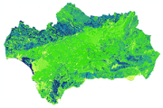
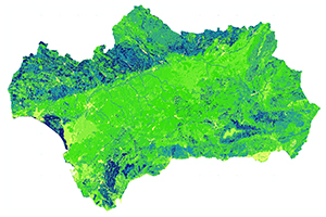
Grid del Número de Curva en condición antecedente de humedad II. Andalucía
Se trata del grid del número de curva en condición antecedente de humedad II para el claculo de la escorrentia por el método propuesto por el SCS. Ha sido realizado a partir del Mapa de suelos de Andalucía a escala 1:400.000, y del Mapa de usos y coberturas vegetales del suelo de Andalucía a escala 1:25.000 de año 2007. Generado en abril de 2012.
Simple
- Date (Creation)
- 2012-04-30
- Citation identifier
- Sin identificador
- Presentation form
- Digital image
- Purpose
-
Utilizacion en estudios hidrologicos en Andalucía
- Point of contact
-
Organisation name Individual name Electronic mail address Role Consejería de Medio Ambiente y Ordenación del Territorio. Junta de Andalucía
Distributor
- Theme
-
-
hidrología
-
escorrentía
-
-
GEMET - INSPIRE themes, version 1.0
-
-
Zonas de riesgos naturales
-
- Use limitation
-
Para saber la licencia hay que mirar el campo de acceso y uso.
- Access constraints
- Other restrictions
- Use constraints
- Other restrictions
- Spatial representation type
- Grid
- Language
- Spanish; Castilian
- Character set
- UTF8
- Topic category
-
- Climatology, meteorology, atmosphere
- Inland waters
))
- Supplemental Information
-
060102
- Reference system identifier
- EPSG:25830
- Reference system identifier
- INSPIRE RS registry / http://www.opengis.net/def/crs/EPSG/0/4258
- Distribution format
-
Name Version Raster
- Units of distribution
-
Datos en descarga
- OnLine resource
-
Protocol Linkage Name WWW:LINK-1.0-http--related
http://descargasrediam.cica.es/repo/s/RUR?path=%2F06_RIESGOS_NATURALES_TECNOLOG%2F01_RIESGOS_NATURALES%2F02_RIESGOS_INUNDACION%2FNumeroCurvaHumed_Escorrentia Descarga Grid del Número de Curva en condición antecedente de humedad II. Andalucía (NumeroCurvaHumed_Escorrentia)
- Hierarchy level
- Dataset
Conformance result
- Date (Publication)
- 2010-12-08
Citation identifier
- Explanation
-
Consultar el reglamento mencionado
- Pass
- Yes
- Description
-
Grid del número de curva en condicion antecedente de humedad II
- Date / Time
- 2012-04-30T00:00:00
- Description
-
Mapa de suelos de Andalucía a escala 1:400.000. Mapa de usos y coberturas vegetales del suelo de Andalucía a escala 1:25.000 del año 2007
- File identifier
- e065dbe4-9539-4e5a-8507-45c5a29fb77e XML
- Metadata language
- Spanish; Castilian
- Character set
- UTF8
- Hierarchy level
- Dataset
- Date stamp
- 2022-09-01T10:37:42
- Metadata standard name
-
ISO 19115 "NEM"
- Metadata standard version
-
2003 "1.0"
- Metadata author
-
Organisation name Individual name Electronic mail address Role Consejería de Sostenibilidad, Medio Ambiente y Economía Azul. Junta de Andalucía
Author
Overviews
Spatial extent
Provided by
