 Catálogo REDIAM
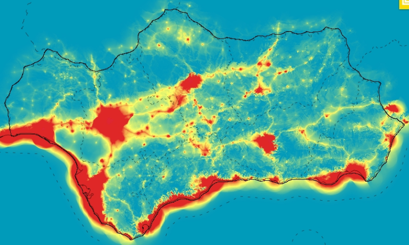
REDIAM. WMS Mapa de accesibilidad visual ponderada. Sistema de visibilidad de Andalucía
Servicio WMS correspondiente al mapa que representa, para cada punto del territorio, el impacto visual de una determinada intervención situada a 0, 10, 20, 30, 60 y 120m de altura. Nodo de la Red de Información Ambiental de Andalucía. Junta de Andalucía. Integrado en la Infraestructura de Datos Espaciales de Andalucía, siguiendo las directrices del Sistema Cartográfico de Andalucía.
Simple
- Date (Revision)
- 2015-01-28T08:44:30
- Status
- Completed
- Point of contact
-
Organisation name Individual name Electronic mail address Role Consejería de Medio Ambiente y Ordenación del Territorio. Junta de Andalucía
--
Point of contact
- Keywords
-
-
paisaje
-
impacto
-
sistema de información
-
intervención en la naturaleza y el paisaje
-
alteración de paisaje
-
elemento del paisaje
-
protección de paisaje
-
política de conservación del paisaje
-
gestión de paisaje
-
planificación paisajística
-
protección del paisaje
-
Área de protección de paisaje
-
consumo de paisaje
-
utilización de paisaje
-
paisajes protegidos
-
recuperación del paisaje
-
incendios forestales paisaje natural (GEMET)
-
WMS
-
REDIAM
-
Andalucía
-
IDEAndalucia
-
- Theme
-
-
humanInteractionService
-
-
Registro de temas REDIAM
-
-
Incendios forestales
-
- Use limitation
-
Este servicio se puede usar de modo libre y gratuito siempre que se mencione a los autores y propietarios de la información
- Access constraints
- Other restrictions
- Use constraints
- Other restrictions
- Other constraints
-
Creative Commons Reconocimiento 4.0 (CC BY 4.0)
- Service Type
- OGC:WMS
- Service Version
-
1.1.1
- Fees
-
Gratuito
))
- Coupling Type
- Tight
- Contains Operations
- Keywords
-
- Keywords
-
- Distribution format
-
Name Version WMS
1.1.1
- OnLine resource
-
Protocol Linkage Name OGC:WMS-1.1.1-http-get-map
http://www.juntadeandalucia.es/medioambiente/mapwms/REDIAM_accesibilidad_visual_ponderada?
- OnLine resource
-
Protocol Linkage Name GLG:KML-2.0-http-get-map
http://www.juntadeandalucia.es/medioambiente/portal_web/rediam/productos/ServiciosOGC/KML/Cartografia_ambiental/Paisaje/accesibilidad_visual_ponderada.kml KML servicio
- OnLine resource
-
Protocol Linkage Name WWW:LINK-1.0-http--link
http://www.juntadeandalucia.es/medioambiente/site/rediam/menuitem.04dc44281e5d53cf8ca78ca731525ea0/?vgnextoid=a79ac2ec2775a410VgnVCM2000000624e50aRCRD&vgnextchannel=bd3535ba2c003410VgnVCM2000000624e50aRCRD&vgnextfmt=rediam&lr=lang_es Ficha servicio Canal REDIAM
- OnLine resource
-
Protocol Linkage Name WWW:LINK-1.0-http--related
https://portalrediam.cica.es/VisorGenerico/?tipo=WMS&url= Visor genérico Servicios OGC
- Hierarchy level
- Service
Attributes
Conformance result
- Date (Publication)
- 2010-12-08
Citation identifier
- Explanation
-
Consultar el reglamento mencionado
- Pass
- Yes
Conformance result
- Date (Publication)
- 2010-12-08
Citation identifier
- Explanation
-
Consultar el reglamento mencionado
- Pass
- Yes
- File identifier
- f3d0f7e7a1a5630c0aa33867fb4c64ab7513c304 XML
- Metadata language
- Spanish; Castilian
- Character set
- UTF8
- Hierarchy level
- Service
- Date stamp
- 2022-09-01T10:38:17Z
- Metadata standard name
-
ISO 19119/2005
- Metadata standard version
-
1.0
- Metadata author
-
Organisation name Individual name Electronic mail address Role Consejería de Sostenibilidad y Medio Ambiente. Junta de Andalucía
--
Point of contact
Overviews

Spatial extent
Provided by
