 Catálogo REDIAM
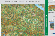
Base cartográfica del mapa Guía Parque Natural Sierra de Hornachuelos del año 2009
Imágenes ráster del Mapa Guía perteneciente al Parque Natural Sierra de Hornachuelos del año 2009 a escala 1:50.000, incluyendo la georreferenciación de los mismos.
Simple
- Date (Creation)
- 2011-04-27
- Citation identifier
- Sin identificador
- Presentation form
- Digital image
- Purpose
-
Base de referencia del Espacio Natural Sierra de Hornachuelos, quedando excluida la representación gráfica susceptible de las actualizaciones (p.e. Equipamientos de Uso Público)
- Status
- Completed
- Point of contact
-
Organisation name Individual name Electronic mail address Role Consejería de Medio Ambiente y Ordenación del Territorio. Junta de Andalucía
Author
- Theme
-
-
Sendero
-
Espacios protegidos
-
IDEAndalucia
-
-
GEMET - INSPIRE themes, version 1.0
-
-
Ortoimágenes
-
- Use limitation
-
Derechos de propiedad intelectual.
- Access constraints
- Intellectual property rights
- Use constraints
- Intellectual property rights
- Spatial representation type
- Grid
- Language
- Spanish; Castilian
- Character set
- UTF8
- Topic category
-
- Imagery base maps earth cover
))
- Supplemental Information
-
0701010901
- Reference system identifier
- EPSG:23030
- Reference system identifier
- INSPIRE RS registry / http://www.opengis.net/def/crs/EPSG/0/4258
- Distribution format
-
Name Version TIFF
PDF
LYR
JPG
- Units of distribution
-
Datos en descarga
- OnLine resource
-
Protocol Linkage Name WWW:LINK-1.0-http--related
http://descargasrediam.cica.es/repo/s/RUR?path=%2F07_PATRIMONIO_NATURAL%2F01_ESPACIOS_PROTEGIDOS%2F01_RENPA%2F09_GUIAS%2F01_MAPAS_GUIA%2FMG_Hornachuelos_2009 Descarga Base cartográfica del mapa Guía Parque Natural Sierra de Hornachuelos del año 2000. (MG_Hornachuelos_2009)
- Units of distribution
-
Publicación web
- OnLine resource
- Units of distribution
-
Servicio WMS
- OnLine resource
-
Protocol Linkage Name http://www.juntadeandalucia.es/medioambiente/mapwms/REDIAM_mapa_guia_pn_hornachuelos_2009? REDIAM. WMS Base cartográfica del mapa guía del Parque Natural Sierra de Hornachuelos del año 2009
- Units of distribution
-
Ficha WMS
- OnLine resource
-
Protocol Linkage Name http://www.juntadeandalucia.es/medioambiente/site/rediam/menuitem.04dc44281e5d53cf8ca78ca731525ea0/?vgnextoid=9176ccee7450f410VgnVCM2000000624e50aRCRD&vgnextchannel=f17a54fdca04f410VgnVCM2000000624e50aRCRD&vgnextfmt=rediam&lr=lang_es Ficha WMS Base cartográfica del mapa guía del Parque Natural Sierra de Hornachuelos del año 2009
- Hierarchy level
- Dataset
Conformance result
- Date (Publication)
- 2010-12-08
Citation identifier
- Explanation
-
Consultar el reglamento mencionado
- Pass
- Yes
- Description
-
Georreferenciación del mapa rasterizado utlizando la herramienta de ArcMap, Georreferencing. Transformación afín, de primer orden.
- Date / Time
- SIN FECHAT00:00:00
- Description
-
Consejería de Medio Ambiente. Consejería de Obras Públicas y Transportes, Instituto de Cartografía de Andalucía.
- File identifier
- f441358d-5e80-42ae-b306-4620e56733f3 XML
- Metadata language
- Spanish; Castilian
- Character set
- UTF8
- Hierarchy level
- Dataset
- Date stamp
- 2022-09-01T10:31:42
- Metadata standard name
-
ISO 19115 "NEM"
- Metadata standard version
-
2003 "1.0"
- Metadata author
-
Organisation name Individual name Electronic mail address Role Consejería de Sostenibilidad, Medio Ambiente y Economía Azul. Junta de Andalucía
Author
Overviews

Spatial extent
Provided by
