Catálogo REDIAM
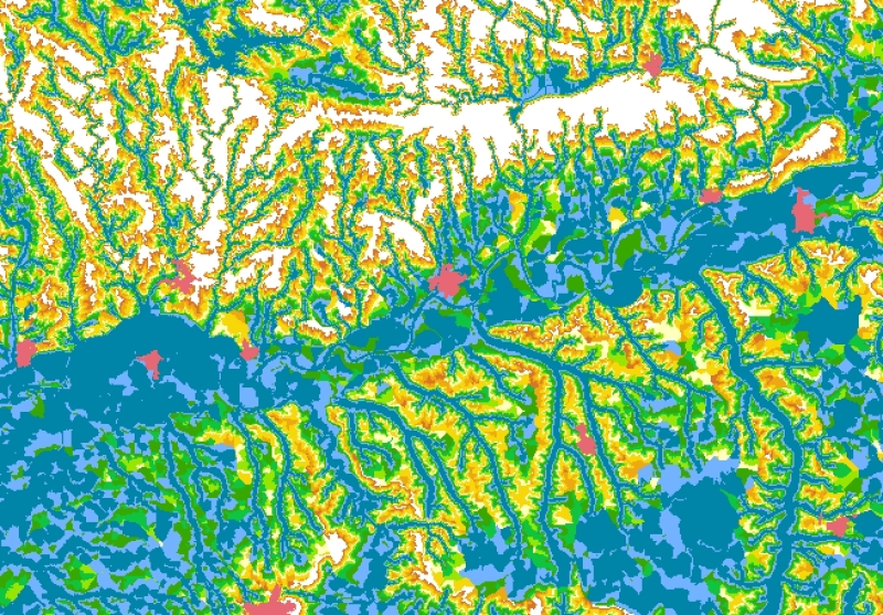
REDIAM. WMS Mapa de Alturas de Inundación de la Cartografía de las Bases de Referencia Hidrológica de Andalucía
Servicio WMS correspondiente al Mapa donde se representan la red hidrográfica y las alturas de inundación en el ámbito de los cuencas hidrológicas que afectan al territorio andaluz. La altura de inundación de un punto del terreno se define como la diferencia de cota entre el punto considerado y la cota del cauce más cercano, siguiendo la línea de máxima pendiente del terreno. Esto equivale a la altura que debe alcanzar el agua en el cauce más cercano para que dicho punto quede cubierto. Nodo de la Red de Información Ambiental de Andalucía. Junta de Andalucía. Integrado en la Infraestructura de Datos Espaciales de Andalucía, siguiendo las directrices del Sistema Cartográfico de Andalucía.
Simple
- Date (Revision)
- 2012-12-18T13:38:42
- Status
- Completed
- Point of contact
-
Organisation name Individual name Electronic mail address Role Consejería de Medio Ambiente y Ordenación del Territorio. Junta de Andalucía
--
Point of contact
- Theme
-
-
WMS
-
Andalucía
-
REDIAM
-
inundaciones
-
hidrología
-
humanInteractionService
-
IDEAndalucia
-
- Use limitation
-
Este servicio se puede usar de modo libre y gratuito siempre que se mencione a los autores y propietarios de la información
- Access constraints
- Other restrictions
- Use constraints
- Other restrictions
- Other constraints
-
Creative Commons Reconocimiento 4.0 (CC BY 4.0)
- Service Type
- OGC:WMS
- Service Version
-
1.1.1
- Fees
-
Gratuito
))
- Coupling Type
- Tight
- Contains Operations
- Distribution format
-
Name Version WMS
1.1.1
- Units of distribution
-
Servicio WMS
- OnLine resource
-
Protocol Linkage Name OGC:WMS-1.1.1-http-get-map
http://www.juntadeandalucia.es/medioambiente/mapwms/REDIAM_Alturas_Inundacion_Andalucia?
- Units of distribution
-
Ficha WMS
- OnLine resource
-
Protocol Linkage Name WWW:LINK-1.0-http--link
https://www.juntadeandalucia.es/medioambiente/portal/landing-page-servicio-ogc/-/asset_publisher/1qlWV3LW9vV6/content/rediam.-wms-mapa-de-alturas-de-inundaci-c3-b3n-de-la-cartograf-c3-ada-de-las-bases-de-referencia-hidrol-c3-b3gica-de-andaluc-c3-ada/20151 Ficha servicio Canal REDIAM
- Hierarchy level
- Service
Attributes
Conformance result
- Date (Publication)
- 2010-12-08
Citation identifier
- Explanation
-
Consultar el reglamento mencionado
- Pass
- Yes
- File identifier
- 04d057a8f2f01486c992aa1392fff87a35addf1f XML
- Metadata language
- Spanish; Castilian
- Character set
- UTF8
- Hierarchy level
- Service
- Date stamp
- 2023-04-14T10:31:24.36Z
- Metadata standard name
-
ISO 19119/2005
- Metadata standard version
-
1.0
- Metadata author
-
Organisation name Individual name Electronic mail address Role Consejería de Sostenibilidad y Medio Ambiente. Junta de Andalucía
--
Point of contact
Overviews
Spatial extent
Provided by