Catálogo REDIAM
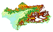
MDE de Andalucía, 1998-99 (20x20m)
Modelo Digital de Elevaciones: Terreno (MDT) del ámbito de Andalucía, generado a partir del vuelo fotogramétrico color (1m), con escala 1:60.000 de 1998-99. Resolución 20x20m. (V006_el)
Simple
- Date (Creation)
- 1998-01-01
- Date (Revision)
- 2008-02-29
- Presentation form
- Digital model
- Purpose
-
Base Cartográfica de Referencia Altimétrica y obtención un modelo a nivel del suelo a partir del cual se obtengan unas ortofotos correctas geométricamente.
- Status
- Historical archive
- Point of contact
-
Organisation name Individual name Electronic mail address Role Consejería de Medio Ambiente. Junta de Andalucía
Author
-
Observación del Territorio
-
-
Observación del Territorio. Producto primario
-
- Theme
-
-
Fotografía aérea
-
Fotogrametría
-
Vuelo de bajo nivel
-
Opendata
-
-
GEMET - INSPIRE themes, version 1.0
-
-
Elevaciones
-
-
Registro de temas REDIAM
-
-
Teledetección y caracterización del territorio
-
- Access constraints
- Other restrictions
- Use constraints
- Other restrictions
- Other constraints
-
Creative Commons Attribution 4.0 International Public License (CC BY 4.0)
- Spatial representation type
- Grid
- Language
- Spanish; Castilian
- Character set
- UTF8
- Topic category
-
- Elevation
))
- Supplemental Information
-
01070101
- Reference system identifier
- EPSG:25830
- Reference system identifier
- INSPIRE RS registry / http://www.opengis.net/def/crs/EPSG/0/4258
- Distribution format
-
Name Version GRID
BMC
- Units of distribution
-
Datos en descarga
- OnLine resource
-
Protocol Linkage Name WWW:LINK-1.0-http--link
https://portalrediam.cica.es/descargas?path=%2F01_CARACTERIZACION_TERRITORIO%2F07_BASES_REF_ELEV%2F01_ELEVACIONES%2F01_PROYECTOS_REGIONALES%2F1998_99_AND_20m_V006_el Descarga MDE de Andalucía, 1998-99 (20x20m)
- Hierarchy level
- Dataset
Conformance result
- Date (Publication)
- 2010-12-08
Citation identifier
- Explanation
-
Consultar el reglamento mencionado
- Pass
- Yes
- Statement
-
Para generar el modelo digital de elevaciones se parte del vuelo fotogramétrico con la información GPS e IMU, el apoyo y la aerotriangulación del proyecto ORTO_AND. A partir de estos datos, se van seguir las siguientes fases: -Generación de líneas de ruptura -Generación del modelo digital del terreno por correlación - Generación de MDT por fusión de líneas de ruptura y datos de correlación editados y depurados.
- Description
-
Generado a partir del vuelo fotogramétrico analógico a escala 1:60.000 en Color en los años 1998 y 1999 de la CMA, COPT(ICA) y DAP.
- File identifier
- 333bf876-042a-44f6-bf57-ee943db6ba8b XML
- Metadata language
- Spanish; Castilian
- Character set
- UTF8
- Hierarchy level
- Dataset
- Date stamp
- 2022-10-20T09:27:58
- Metadata standard name
-
ISO 19115 "NEM"
- Metadata standard version
-
2003 "1.0"
- Metadata author
-
Organisation name Individual name Electronic mail address Role Consejería de Sostenibilidad, Medio Ambiente y Economía Azul. Junta de Andalucía
Author
Overviews

Spatial extent
Provided by