Catálogo REDIAM
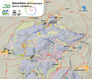
Mapa de Geositios del Geoparque Sierras Subbéticas
Mapa de localización de los lugares de interés geológico (geositios) más destacados del Geoparque Sierras Subbéticas. Incluye una breve descripción de cada geositio. Disponible en español y en inglés.
Simple
- Date (Publication)
- 2019-01-01
- Citation identifier
- Sin identificador
- Presentation form
- Digital document
- Purpose
-
Divulgar los lugares de interés geológico más destacados del Geoparque Sierras Subbéticas.
- Status
- Completed
- Point of contact
-
Organisation name Individual name Electronic mail address Role Consejería de Agricultura, Ganadería, Pesca y Desarrollo Sostenible. Junta de Andalucía
Owner
- Theme
-
-
cartografía
-
geología
-
mapas
-
espacios protegidos
-
Opendata
-
-
GEMET - INSPIRE themes, version 1.0
-
-
Geología
-
-
Registro de temas REDIAM
-
-
Geodiversidad
-
- Access constraints
- Other restrictions
- Use constraints
- Other restrictions
- Other constraints
-
Creative Commons Attribution 4.0 International Public License (CC BY 4.0)
- Spatial representation type
- Language
- Spanish; Castilian
- Character set
- UTF8
- Topic category
-
- Environment
- Geoscientific information
- Location
))
- Supplemental Information
-
\04_RECURSOS_NATURALES\02_GEODIVERSIDAD\06_PRODUCTOS_DIFUSION_GEODIVERSIDAD\MapaGeositios_SSubbeticas
- Distribution format
-
Name Version PDF
- Units of distribution
-
Publicación web
- OnLine resource
-
Protocol Linkage Name WWW:LINK-1.0-http--related
https://www.juntadeandalucia.es/medioambiente/portal/landing-page-%C3%ADndice/-/asset_publisher/zX2ouZa4r1Rf/content/geoparque-sierras-subb-c3-a9ticas/20151? Geoparque Mundial de la Unesco Sierras Subbéticas
- Units of distribution
-
Datos en descarga
- OnLine resource
-
Protocol Linkage Name WWW:LINK-1.0-http--related
https://descargasrediam.cica.es/repo/s/RUR?path=%2F04_RECURSOS_NATURALES%2F02_GEODIVERSIDAD%2F06_PRODUCTOS_DIFUSION_GEODIVERSIDAD%2FMapaGeositios_SSubbeticas Descarga Mapa geositios del Geoparque Sierras Subbéticas. (MapaGeositios_SSubbeticas)
- Hierarchy level
- Dataset
Conformance result
- Date (Publication)
- 2010-12-08
Citation identifier
- Explanation
-
Consultar el reglamento mencionado
- Pass
- Yes
- Description
-
Geología: Mapa Geológico Nacional a escala 1:50.000, Instituto Geológico y Minero de España, 2011. Altimetría y Planimetría: Mapa Topográfico de Andalucía 1:10.000, Junta de Andalucía.
- File identifier
- 46bce586-94b2-4354-9959-8b05b49b68f4 XML
- Metadata language
- Spanish; Castilian
- Character set
- UTF8
- Hierarchy level
- Dataset
- Date stamp
- 2025-03-14T15:11:21.215Z
- Metadata standard name
-
ISO 19115 "NEM"
- Metadata standard version
-
2003 "1.0"
- Metadata author
-
Organisation name Individual name Electronic mail address Role Consejería de Sostenibilidad y Medio Ambiente. Junta de Andalucía
Author
Overviews
Spatial extent
Provided by