Catálogo REDIAM
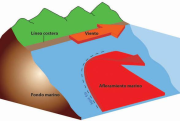
Zonas de afloramientos (up-welling) en el medio marino de influencia en Andalucía. Universidad de Sevilla
Delimitación aproximada de zonas de afloramientos de aguas profundas (up-welling). Este fenómeno tienen un importante rol en la productividad primaria de las aguas donde se producen, siendo por tanto zonas que deben considerarse de especial relevancia desde el punto de vista ambiental y económico (pesca) y por tanto deben ser consideradas en iniciativas de planificación o regionalización del medio marino.
Simple
- Date (Creation)
- 2011-01-03
- Citation identifier
- Sin identificador
- Presentation form
- Digital map
- Purpose
-
Localizar de forma aproximada las principales zonas de up-welling en la costa andaluza.
- Status
- Historical archive
- Point of contact
-
Organisation name Individual name Electronic mail address Role Consejería de Agricultura, Pesca y Medio Ambiente. Junta de Andalucía
Distributor
-
Registro de temas REDIAM
-
-
Litoral
-
- Theme
-
-
Pesquería marina
-
Ecosistemas marinos
-
Aguas marinas
-
IDEAndalucia
-
Opendata
-
-
GEMET - INSPIRE themes, version 1.0
-
-
Regiones marinas
-
- Access constraints
- Other restrictions
- Use constraints
- Other restrictions
- Other constraints
-
Creative Commons Attribution 4.0 International Public License (CC BY 4.0)
- Spatial representation type
- Vector
- Denominator
- 1000000
- Language
- Spanish; Castilian
- Character set
- UTF8
- Topic category
-
- Biota
- Environment
- Oceans
))
- Supplemental Information
-
/Inf_archivo/08_AMBITOS_INTERES_AMBIENTAL/02_LITORAL_MARINO/01_HIDRODINAMICA/Afloramientos/Metadatos
- Reference system identifier
- EPSG:23030
- Reference system identifier
- EPSG:25830
- Reference system identifier
- INSPIRE RS registry / http://www.opengis.net/def/crs/EPSG/0/4258
- Distribution format
-
Name Version ESRI Shapefile
1.0
- Units of distribution
-
Datos en descarga
- OnLine resource
-
Protocol Linkage Name WWW:LINK-1.0-http--related
https://portalrediam.cica.es/descargas?path=%2FInf_archivo%2F08_AMBITOS_INTERES_AMBIENTAL%2F02_LITORAL_MARINO%2F01_HIDRODINAMICA%2FAfloramientos Descarga Zonas de afloramientos (up-welling) en el medio marino de influencia en Andalucía. Universidad de Sevilla (Afloramientos)
- Hierarchy level
- Dataset
Conformance result
- Date (Publication)
- 2010-12-08
Citation identifier
- Explanation
-
Consultar el reglamento mencionado
- Pass
- Yes
- Statement
-
A partir del mapa geomorfológico de España y el margen continental escala 1:1.000.000 publicado por el IGME, se realiza un proceso de georreferenciación y posterior digitalización de los polígonos que representan las zonas de afloramiento de aguas profundas.
- Description
-
Mapa geomorfológico submarino del litoral español (IGME)
- File identifier
- 491d757b-9680-49ed-b349-fa1660cb8337 XML
- Metadata language
- Spanish; Castilian
- Character set
- UTF8
- Hierarchy level
- Dataset
- Date stamp
- 2024-11-12T11:23:58.853Z
- Metadata standard name
-
ISO 19115 "NEM"
- Metadata standard version
-
2003 "1.0"
- Metadata author
-
Organisation name Individual name Electronic mail address Role Consejería de Sostenibilidad y Medio Ambiente. Junta de Andalucía
Author
Overviews
Spatial extent
Provided by