Catálogo REDIAM
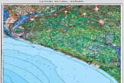
Base cartográfica del mapa Guía Parque Nacional y Natural de Doñana del año 2011
Imágenes ráster del Mapa Guía Parque Nacional y Natural de Doñana año 2011 a escala 1:75.000, incluyendo la georreferenciación de los mismos.
Simple
- Date (Creation)
- 2013-04-01
- Citation identifier
- Sin identificador
- Presentation form
- Digital image
- Purpose
-
Base de referencia del Espacio Natural de Doñana, quedando excluida la representación gráfica susceptible de actualizaciones (p.e. Equipamientos de Uso Público)
- Status
- Historical archive
- Point of contact
-
Organisation name Individual name Electronic mail address Role Consejería de Medio Ambiente y Ordenación del Territorio. Junta de Andalucía
Author
- Theme
-
-
mapa
-
Espacios protegidos
-
IDEAndalucia
-
-
GEMET - INSPIRE themes, version 1.0
-
-
Ortoimágenes
-
- Use limitation
-
Derechos de propiedad intelectual.
- Access constraints
- Intellectual property rights
- Use constraints
- Intellectual property rights
- Spatial representation type
- Grid
- Language
- Spanish; Castilian
- Character set
- UTF8
- Topic category
-
- Boundaries
- Environment
- Imagery base maps earth cover
))
- Supplemental Information
-
0701010901
- Reference system identifier
- EPSG:25829
- Reference system identifier
- INSPIRE RS registry / http://www.opengis.net/def/crs/EPSG/0/4258
- Distribution format
-
Name Version TIF
PDF
LYR
JPG
- Units of distribution
-
Datos en descarga
- OnLine resource
-
Protocol Linkage Name http://descargasrediam.cica.es/repo/s/RUR?path=%2F07_PATRIMONIO_NATURAL%2F01_ESPACIOS_PROTEGIDOS%2F01_RENPA%2F09_GUIAS%2F01_MAPAS_GUIA%2FMG_Donana_2011 Descarga Base cartográfica del mapa Guía Parque Nacional y Natural de Doñana del año 2011 (MG_Donana_2011)
- Units of distribution
-
Publicación web
- OnLine resource
-
Protocol Linkage Name http://www.juntadeandalucia.es/medioambiente/portal_web/rediam/imagenes/mapasguia/MG_Donana_2011_I.jpg PN_Donana_2011_I
- Units of distribution
-
Publicación web
- OnLine resource
-
Protocol Linkage Name http://www.juntadeandalucia.es/medioambiente/portal_web/rediam/imagenes/mapasguia/MG_Donana_2011_II.jpg MG_Donana_2011_II.jpg
- Units of distribution
-
Servicio WMS
- OnLine resource
-
Protocol Linkage Name https://www.juntadeandalucia.es/medioambiente/portal/web/guest/landing-page-servicio-ogc/-/asset_publisher/1qlWV3LW9vV6/content/rediam.-wms-base-cartogr-c3-a1fica-del-mapa-gu-c3-ada-parque-natural-do-c3-b1ana-del-a-c3-b1o-2011/20151 REDIAM. WMS Base cartográfica del mapa guía del Parque Natural Doñana del año 2011
- Units of distribution
-
Datos en descarga
- OnLine resource
-
Protocol Linkage Name WWW:LINK-1.0-http--related
http://descargasrediam.cica.es/repo/s/RUR?path=%2F07_PATRIMONIO_NATURAL%2F01_ESPACIOS_PROTEGIDOS%2F01_RENPA%2F09_GUIAS%2F01_MAPAS_GUIA%2FMG_Donana_2011 Descarga Base cartográfica del mapa Guía Parque Nacional y Natural de Doñana del año 2011 (MG_Donana_2011)
- Hierarchy level
- Dataset
Conformance result
- Date (Publication)
- 2010-12-08
Citation identifier
- Explanation
-
Consultar el reglamento mencionado
- Pass
- Yes
- Statement
-
Georreferenciado de la imagen RASTER del Mapa Guía del Parque Nacional y Natural de Doñana año 2011
- Description
-
Georreferenciación del mapa rasterizado utilizando la herramienta de ArcMap, Georreferencing. Transformación afín, de primer orden.
Sistema de referencia definido ED50, transformado a ETRS89
- Date / Time
- 2013-04-01T00:00:00
- Description
-
Consejería de Medio Ambiente. Consejería de Obras Públicas y Transportes, Instituto de Cartografía de Andalucía.
- File identifier
- 54766d92-9b6f-4ff3-9ef7-4a25208640f7 XML
- Metadata language
- Spanish; Castilian
- Character set
- UTF8
- Hierarchy level
- Dataset
- Date stamp
- 2022-09-05T06:22:24
- Metadata standard name
-
ISO 19115 "NEM"
- Metadata standard version
-
2003 "1.0"
- Metadata author
-
Organisation name Individual name Electronic mail address Role Consejería de Sostenibilidad, Medio Ambiente y Economía Azul. Junta de Andalucía
Author
Overviews
Spatial extent
Provided by