Catálogo REDIAM
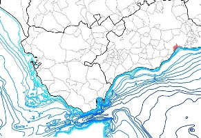
Batimetría del litoral andaluz 1:400000, año 2000
Representación de las curvas de nivel en metros (isóbatas) que corresponden a los límites que definen la zona litoral, la plataforma continental, talud continental y llanura abisal. Corresponden a las profundidades de: 10, 20 30, 40, 50, 60, 70, 80, 90, 100, 200, 300, 400, 500, 600, 700, 800, 900, 1000, 1200, 1400, 1600, 1800 y 2000 m.
Simple
- Date (Creation)
- 2000-01-01
- Citation identifier
- Sin identificador
- Presentation form
- Digital map
- Purpose
-
Cartografiar el relieve de los fondos marinos del sector andaluz. Se trata de una generalización con fines exclusivamente cartográficos, de las isobatas contenidas en las cartas náuticas del IHM (Atlas de Andalucía). No se incluyen todas las isobatas de aguas poco profundas ni las cotas puntuales presentes en estas cartas.
- Credit
-
Estudios Geológicos Marinos - ESGEMAR, S.A Universidad de Sevilla
- Status
- Completed
- Point of contact
-
Organisation name Individual name Electronic mail address Role Consejería de Medio Ambiente. Junta de Andalucía
Owner
-
Registro de temas REDIAM
-
-
Litoral
-
- Theme
-
-
Litoral
-
Modelos digitales del terreno
-
Fondo marino
-
IDEAndalucia
-
Opendata
-
-
GEMET - INSPIRE themes, version 1.0
-
-
Rasgos geográficos oceanográficos
-
- Use limitation
-
Derechos de propiedad intelectual
- Access constraints
- Other restrictions
- Use constraints
- Other restrictions
- Other constraints
-
Creative Commons Attribution 4.0 International Public License (CC BY 4.0)
- Spatial representation type
- Vector
- Denominator
- 400000
- Language
- Spanish; Castilian
- Character set
- UTF8
- Topic category
-
- Elevation
- Oceans
))
- Supplemental Information
-
080206
- Reference system identifier
- EPSG:23030
- Reference system identifier
- INSPIRE RS registry / http://www.opengis.net/def/crs/EPSG/0/4258
- Distribution format
-
Name Version ESRI Shapefile
1.0
- Units of distribution
-
Datos en descarga
- OnLine resource
-
Protocol Linkage Name WWW:LINK-1.0-http--related
https://portalrediam.cica.es/descargas?path=%2F08_AMBITOS_INTERES_AMBIENTAL%2F02_LITORAL_MARINO%2F06_BATIMETRIAS%2FBatimetria400000 Batimetría del litoral andaluz a escala 1:400000 (Batimetria400000)
- Units of distribution
-
Servicio WMS
- OnLine resource
-
Protocol Linkage Name OGC:WMS-1.3.0-http-get-map
http://www.juntadeandalucia.es/medioambiente/mapwms/REDIAM_batimetria_escala_400000_litoral_andaluz? WMS Batimetría del litoral andaluz. Año 2000. Escala 1:400.000
- Units of distribution
-
Ficha WMS
- OnLine resource
-
Protocol Linkage Name WWW:LINK-1.0-http--related
http://www.juntadeandalucia.es/medioambiente/site/rediam/menuitem.04dc44281e5d53cf8ca78ca731525ea0/?vgnextoid=34491d5336b37310VgnVCM2000000624e50aRCRD&vgnextchannel=4a26fa937370f210VgnVCM1000001325e50aRCRD&vgnextfmt=rediam&lr=lang_es Ficha WMS Batimetría del litoral andaluz. Año 2000. Escala 1:400.000
- Hierarchy level
- Dataset
Conformance result
- Date (Publication)
- 2010-12-08
Citation identifier
- Explanation
-
Consultar el reglamento mencionado
- Pass
- Yes
- Statement
-
Cartografía del Medio Submarino realizada por ESGEMAR para la CMA, tomando como referencia geométrica para su digitalización el Atlas de Andalucía 1:400.000 y como fuente principal de los datos la cartografía del Instituto Hidrográfico de la Marina y, en las áreas costeras, trabajos específicos e inéditos.
- Description
-
No disponible
- Date / Time
- 2000-01-01T00:00:00
- Description
-
Atlas de Andalucía 1:400.000. Cartas náuticas del Instituto Hidrográfico de la Marina. Trabajos específicos e inéditos
- File identifier
- 8e94493a-be52-48fa-8da9-81f7bc2de51d XML
- Metadata language
- Spanish; Castilian
- Character set
- UTF8
- Hierarchy level
- Dataset
- Date stamp
- 2022-09-02T06:34:11Z
- Metadata standard name
-
ISO 19115 "NEM"
- Metadata standard version
-
2003 "1.0"
- Metadata author
-
Organisation name Individual name Electronic mail address Role Consejería de Sostenibilidad y Medio Ambiente. Junta de Andalucía
Author
Overviews

Spatial extent
Provided by