Catálogo REDIAM
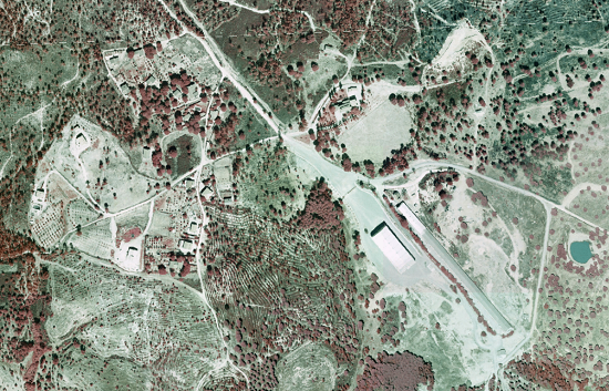
Ortofotografía incendio de Calañas (Huelva), 2004
Ortofoto del ámbito afectado por el incendio de Calañas (Huelva) de 0.20m de resolución con fecha en el año 2004, generada a partir de vuelo fotogramétrico Analógico a escala desconocida. (V096_of)
Simple
- Date (Creation)
- 2004-09-18
- Date (Revision)
- 2008-02-29
- Presentation form
- Digital image
- Purpose
-
Disponibilidad de Base de referencia cartográfica para el seguimiento de la zona afectada por el incendio. La evaluación de daños o proyectos de restauración.
- Status
- Completed
- Point of contact
-
Organisation name Individual name Electronic mail address Role Consejería de Medio Ambiente. Junta de Andalucía
Author
-
Observación del Territorio
-
-
Observación del Territorio. Producto primario
-
-
Registro de temas REDIAM
-
-
Incendios forestales
-
- Theme
-
-
Fotografía aérea
-
Fotogrametría
-
Vuelo de bajo nivel
-
Vuelo de bajo nivel
-
Vuelo de bajo nivel
-
IDEAndalucia
-
Opendata
-
-
GEMET - INSPIRE themes, version 1.0
-
-
Ortoimágenes
-
- Use limitation
-
Para saber la licencia hay que mirar el campo de acceso y uso.
- Access constraints
- Other restrictions
- Use constraints
- Other restrictions
- Other constraints
-
Creative Commons Attribution 4.0 International Public License (CC BY 4.0)
- Spatial representation type
- Grid
- Language
- Spanish; Castilian
- Character set
- UTF8
- Topic category
-
- Imagery base maps earth cover
))
- Supplemental Information
-
01020102
- Reference system identifier
- EPSG:23030
- Reference system identifier
- INSPIRE RS registry / http://www.opengis.net/def/crs/EPSG/0/4258
- Distribution format
-
Name Version MrSID
Shape
- Units of distribution
-
Servicio WMS
- OnLine resource
-
Protocol Linkage Name OGC:WMS-1.3.0-http-get-map
http://www.juntadeandalucia.es/medioambiente/mapwms/REDIAM_Ortofoto_Calanas_2004? REDIAM. Ortofoto de 0.20 m de resolución obtenida a partir del Vuelo Fotogramétrico del Incendio de Calañas (Huelva) de 2004
- Units of distribution
-
Ficha WMS
- OnLine resource
-
Protocol Linkage Name OGC:WMS-1.3.0-http-get-map
http://www.juntadeandalucia.es/medioambiente/site/rediam/menuitem.04dc44281e5d53cf8ca78ca731525ea0/?vgnextoid=1f5dfabfab2dc110VgnVCM1000001325e50aRCRD&vgnextchannel=90e122ad8470f210VgnVCM1000001325e50aRCRD&vgnextfmt=rediam&lr=lang_es WMS Ortofoto incendio Calañas (Huelva) color infrarrojo (CIR) de 2004
- Units of distribution
-
Datos en descarga
- OnLine resource
-
Protocol Linkage Name WWW:LINK-1.0-http--related
http://descargasrediam.cica.es/repo/s/RUR?path=%2F01_CARACTERIZACION_TERRITORIO%2F02_BASES_REF_ORTOFOTOS_ORTOIMAGENES%2F01_ORTOFOTOS%2F02_PROYECTOS_LOCALES%2F2004_09_18_HU_Calanas_0.20m_V096_of Descarga Ortofotografía incendio de Calañas (Huelva), 2004 (2004_09_18_HU_Calanas_0.20m_V096_of)
- Hierarchy level
- Dataset
Conformance result
- Date (Publication)
- 2010-12-08
Citation identifier
- Explanation
-
Consultar el reglamento mencionado
- Pass
- Yes
- Statement
-
Para generar la ortofotografía se utiliza la información proporcionada por el vuelo fotogramétrico, el apoyo de campo, la aerotriangulación y el modelo digital de elevaciones.
- Description
-
Vuelo fotogramétrico analógico a partir de la escala 1:15.000 del año 2004 en CIR de la Consejería de Medio Ambiente.
- File identifier
- ad9247f5-91e8-4621-bb44-1073a6115692 XML
- Metadata language
- Spanish; Castilian
- Character set
- UTF8
- Hierarchy level
- Dataset
- Date stamp
- 2022-09-01T11:37:02
- Metadata standard name
-
ISO 19115 "NEM"
- Metadata standard version
-
2003 "1.0"
- Metadata author
-
Organisation name Individual name Electronic mail address Role Consejería de Sostenibilidad, Medio Ambiente y Economía Azul. Junta de Andalucía
Author
Overviews

Spatial extent
Provided by