 Catálogo REDIAM
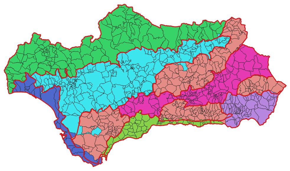
Áreas geográficas para la elaboración de estadísticas climáticas. Andalucía
Cobertura en formato vectorial de áreas geográficas en Andalucía. Estas áreas se utilizan para la generación de estadísticas climáticas.
Simple
- Date (Creation)
- 2001-07-05
- Date (Publication)
- 2009-01-01
- Citation identifier
- Sin identificador
- Presentation form
- Digital map
- Purpose
-
Informe de Medio Ambiente en Andalucía
- Status
- Completed
- Point of contact
-
Organisation name Individual name Electronic mail address Role Consejería de Medio Ambiente. Junta de Andalucía
Author
- Theme
-
-
Tipos climáticos
-
IDEAndalucia
-
Opendata
-
-
GEMET - INSPIRE themes, version 1.0
-
-
Aspectos geográficos de carácter meteorológico
-
- Use limitation
-
Para saber la licencia hay que mirar el campo de acceso y uso.
- Access constraints
- Other restrictions
- Use constraints
- Other restrictions
- Other constraints
-
Creative Commons Attribution 4.0 International Public License
- Spatial representation type
- Vector
- Denominator
- 500000
- Language
- Spanish; Castilian
- Character set
- UTF8
- Topic category
-
- Climatology, meteorology, atmosphere
- Environment
))
- Supplemental Information
-
04030209
- Reference system identifier
- EPSG:25830
- Reference system identifier
- INSPIRE RS registry / http://www.opengis.net/def/crs/EPSG/0/4258
- Distribution format
-
Name Version Pdf
ESRI Shapefile
1.0
- Units of distribution
-
Datos en descarga
- OnLine resource
-
Protocol Linkage Name WWW:LINK-1.0-http--related
http://descargasrediam.cica.es/repo/s/RUR?path=%2F04_RECURSOS_NATURALES%2F03_CLIMA%2F02_CARACTERIZACION_CLIMATICA%2F09_CLASIFICACIONES%2FAREAS_GEOGRAFICAS Descarga Áreas geográficas para la elaboración de estadísticas climáticas. Andalucía (AREAS_GEOGRAFICAS)
- Units of distribution
-
Servicio WMS
- OnLine resource
-
Protocol Linkage Name http://www.juntadeandalucia.es/medioambiente/mapwms/REDIAM_areas_geograficas_climaticas REDIAM. Áreas geográficas para la elaboración de estadísticas climáticas.
- Units of distribution
-
Ficha WMS
- OnLine resource
-
Protocol Linkage Name http://www.juntadeandalucia.es/medioambiente/site/rediam/menuitem.04dc44281e5d53cf8ca78ca731525ea0/?vgnextoid=351a8552ae67e210VgnVCM2000000624e50aRCRD&vgnextchannel=2532fa937370f210VgnVCM1000001325e50aRCRD&vgnextfmt=rediam&lr=lang_es WMS Mapa de Áreas geográficas para la elaboración de estadísticas climáticas
- Hierarchy level
- Dataset
Conformance result
- Date (Publication)
- 2010-12-08
Citation identifier
- Explanation
-
Consultar el reglamento mencionado
- Pass
- Yes
- Statement
-
Delimitación de Andalucía por áreas geográficas teniendo en cuenta la establecida en el tomo II de la obra "Geografía de Andalucía" (Tartessos, 1987). Los límites se han ajustado en lo posible a los límites municipales con objeto de asignar por completo cada municipio a un área geográfica.
- Description
-
Normalización de la información por la Consejería de Medio Ambiente. Superado el control de calidad de estructura, la información es normalizada por un técnico del Servicio contratante y remitida al Servicio de Información y Evaluación Ambiental para su integración en los sistemas de almacenamiento de la REDIAM
- Description
-
Compendio de Cartografía y Estadística. 2001. Consejería de Medio Ambiente.
- File identifier
- b38e5159-f179-40c9-9224-6d72c18679ac XML
- Metadata language
- Spanish; Castilian
- Character set
- UTF8
- Hierarchy level
- Dataset
- Date stamp
- 2022-09-01T11:35:53
- Metadata standard name
-
ISO 19115 "NEM"
- Metadata standard version
-
2003 "1.0"
- Metadata author
-
Organisation name Individual name Electronic mail address Role Consejería de Sostenibilidad, Medio Ambiente y Economía Azul. Junta de Andalucía
Author
Overviews

Spatial extent
Provided by
