Catálogo REDIAM
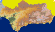
Mapa Hipsométrico de Andalucía 1:100000
Imagen ráster reproduciendo un mapa hipsométrico que representa la altitud del terrritorio Andaluz mediante diferentes graduaciones de color extraído de un modelo de elevaciones de 20 m. de resolución a escala 1:100.000.
Simple
- Date (Creation)
- 2003-04-04
- Citation identifier
- Sin identificador
- Presentation form
- Digital map
- Purpose
-
Utilización como base de referencia para la realización de mapas temáticos medioambientales.
- Status
- Completed
- Point of contact
-
Organisation name Individual name Electronic mail address Role Consejería de Medio Ambiente y Ordenación del Territorio. Junta de Andalucía
Author
- Theme
-
-
Mapas
-
Cartografía
-
Modelos digitales de terreno
-
IDEAndalucia
-
-
GEMET - INSPIRE themes, version 1.0
-
-
Elevaciones
-
- Access constraints
- Other restrictions
- Use constraints
- Other restrictions
- Other constraints
-
Creative Commons Attribution 4.0 International Public License
- Spatial representation type
- Grid
- Language
- Spanish; Castilian
- Character set
- UTF8
- Topic category
-
- Elevation
- Imagery base maps earth cover
))
- Supplemental Information
-
0101
- Reference system identifier
- EPSG:23030
- Reference system identifier
- INSPIRE RS registry / http://www.opengis.net/def/crs/EPSG/0/4258
- Distribution format
-
Name Version MrSid
JP2
- Units of distribution
-
Datos en descarga
- OnLine resource
-
Protocol Linkage Name WWW:LINK-1.0-http--related
http://descargasrediam.cica.es/repo/s/RUR?path=%2F01_CARACTERIZACION_TERRITORIO%2F01_BASES_REF_TOPOGRAFICAS%2FMapa_hipsometrico_100000_CMA Descarga Mapa_hipsometrico_100000_CMA (Mapa_hipsometrico_100000_CMA)
- Units of distribution
-
Servicio WMS
- OnLine resource
-
Protocol Linkage Name OGC:WMS-1.3.0-http-get-map
http://www.juntadeandalucia.es/medioambiente/mapwms/REDIAM_mapa_hipsometrico_100000 REDIAM. WMS Mapa hipsométrico a escala 1:100.000 del año 2003. Consejería de Agricultura, Pesca y Medio Ambiente, Junta de Andalucía
- Units of distribution
-
Ficha WMS
- OnLine resource
-
Protocol Linkage Name WWW:LINK-1.0-http--related
http://www.juntadeandalucia.es/medioambiente/site/rediam/menuitem.04dc44281e5d53cf8ca78ca731525ea0/?vgnextoid=0462d534ee01d310VgnVCM1000001325e50aRCRD&vgnextchannel=33be7c119370f210VgnVCM2000000624e50aRCRD&vgnextfmt=rediam&lr=lang_es Ficha WMS Mapa hipsométrico a escala 1:100.000. Año 2003
- Units of distribution
-
Kml
- OnLine resource
-
Protocol Linkage Name WWW:LINK-1.0-http--related
http://www.juntadeandalucia.es/medioambiente/portal_web/rediam/productos/ServiciosOGC/KML/Cartografia_ambiental/Localizacion_geografica/mapa_hipsometrico_100000.kml Fichero mapa_hipsometrico_100000.kml
- Hierarchy level
- Dataset
Conformance result
- Date (Publication)
- 2010-12-08
Citation identifier
- Explanation
-
Consultar el reglamento mencionado
- Pass
- Yes
- File identifier
- e902ffe7-018f-4b21-b9ca-af1353487025 XML
- Metadata language
- Spanish; Castilian
- Character set
- UTF8
- Hierarchy level
- Dataset
- Date stamp
- 2022-09-01T10:44:06
- Metadata standard name
-
ISO 19115 "NEM"
- Metadata standard version
-
2003 "1.0"
- Metadata author
-
Organisation name Individual name Electronic mail address Role Consejería de Sostenibilidad y Medio Ambiente. Junta de Andalucía
Author
Overviews

Spatial extent
Provided by