Catálogo REDIAM
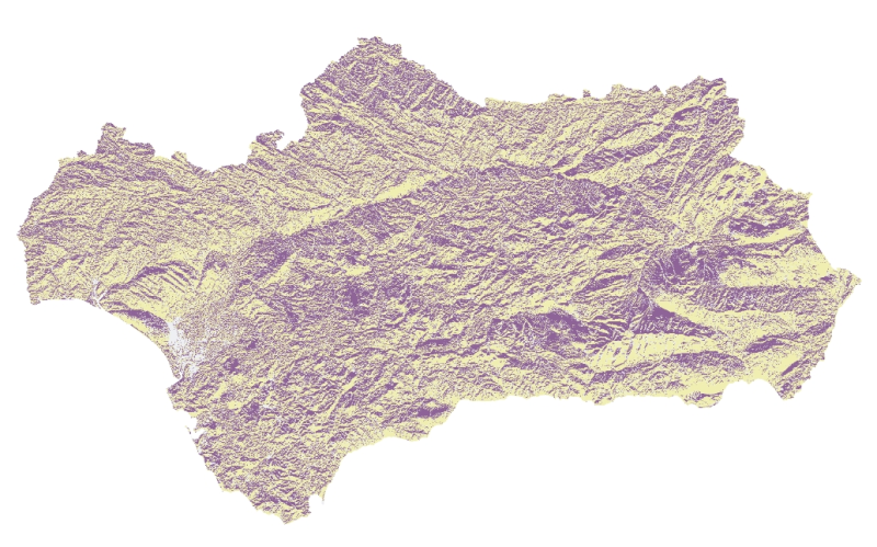
REDIAM. WMS Mapa de Orientaciones de 10x10 de Andalucía. Año 2010-2011
Servicio WMS que permite la visualización del Mapa de Orientaciones de Andalucía de 10 m de resolución para escalas mayores a la 1:200.000, generado a partir del MDT de malla 10x10 m de 2010-11 de Andalucía. Cada píxel del terreno queda clasificado según su orientación esté en solana o umbría. Nodo de la Red de Información Ambiental de Andalucía. Junta de Andalucía. Integrado en la Infraestructura de Datos Espaciales de Andalucía, siguiendo las directrices del Sistema Cartográfico de Andalucía.
Simple
Identification info
- Date (Publication)
- 2014-01-31T10:05:56
- Point of contact
-
Organisation name Individual name Electronic mail address Role Consejería de Medio Ambiente y Ordenación del Territorio. Junta de Andalucía
--
Point of contact
- Keywords
-
-
WMS
-
Andalucía
-
REDIAM
-
Orientación
-
grado
-
clasificación
-
biomasa
-
- Theme
-
-
humanInteractionService
-
IDEAndalucia
-
-
Registro de temas REDIAM
-
-
Teledetección y caracterización del territorio
-
-
GEMET - INSPIRE themes, version 1.0
-
-
Elevaciones
-
- Use limitation
-
Este servicio se puede usar de modo libre y gratuito siempre que se mencione a los autores y propietarios de la información
- Access constraints
- Other restrictions
- Use constraints
- Other restrictions
- Other constraints
-
Creative Commons Reconocimiento 4.0 (CC BY 4.0)
- Service Type
- OGC:WMS
- Service Version
-
1.3.0
- Fees
-
Gratuito
))
- Coupling Type
- Tight
- Contains Operations
- Distribution format
-
Name Version WMS
1.3.0
- Units of distribution
-
Servicio WMS
- OnLine resource
-
Protocol Linkage Name OGC:WMS-1.3.0-http-get-map
https://www.juntadeandalucia.es/medioambiente/mapwms/REDIAM_orientaciones_andalucia? REDIAM. WMS Mapa de Orientaciones de 10x10 de Andalucía. Año 2010-2011
- Units of distribution
-
Ficha Canal REDIAM
- OnLine resource
-
Protocol Linkage Name WWW:LINK-1.0-http--link
https://www.juntadeandalucia.es/medioambiente/portal/landing-page-servicio-ogc/-/asset_publisher/1qlWV3LW9vV6/content/rediam.-wms-mapa-de-orientaciones-de-100m-de-andaluc-c3-ada-2006- Ficha WMS Mapa de Orientaciones de 10x10 de Andalucía. Año 2010-2011
- Hierarchy level
- Service
Attributes
Conformance result
- Date (Publication)
- 2010-12-08
Citation identifier
- Explanation
-
Consultar el reglamento mencionado
- Pass
- Yes
- File identifier
- f04076068e9ac84a78afb2d2ffb67a15df4622e7 XML
- Metadata language
- Spanish; Castilian
- Character set
- UTF8
- Hierarchy level
- Service
- Date stamp
- 2025-10-22T07:42:26.177Z
- Metadata standard name
-
ISO 19119/2005
- Metadata standard version
-
1.0
- Metadata author
-
Organisation name Individual name Electronic mail address Role Consejería de Sostenibilidad y Medio Ambiente. Junta de Andalucía
--
Point of contact
Overviews

Spatial extent
Provided by