Catálogo REDIAM
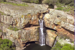
Inventario de Lugares de Interés Hidrogeológico (LIH) de Andalucía. 2006
El presente contenido se enmarca en una de las actividades contempladas en el Convenio entre la Agencia Andaluza del Agua y el Instituto Geológico y Minero de España (IGME). En particular, esta actividad se centra en la identificación de los principales Lugares de Interés Hidrogeológico (LIH) distribuidos en toda la geografía regional andaluza y que tienen particular interés por el patrimonio cultural, social, medioambiental, didáctico, recreativo, científico y funcional que integran. Escala 1:10.000. Año 2006.
Simple
- Date (Creation)
- 2006-12-18
- Presentation form
- Digital document
- Purpose
-
Conocer los lugares de interés hidrogeológico en Andalucía, su localización y características.
- Status
- Historical archive
- Point of contact
-
Organisation name Individual name Electronic mail address Role Consejería de Sostenibilidad y Medio Ambiente. Junta de Andalucía
Point of contact Instituto Geológico y Minero de España
Originator
- Theme
-
-
hidrogeología
-
protección de las aguas subterráneas
-
aguas superficiales
-
IDEAndalucia
-
Opendata
-
-
Registro de temas REDIAM
-
-
Geodiversidad
-
Agua
-
-
GEMET - INSPIRE themes, version 1.0
-
-
Hidrografía
-
Geología
-
- Access constraints
- Other restrictions
- Use constraints
- Other restrictions
- Other constraints
-
Creative Commons Attribution 4.0 International Public License (CC BY 4.0)
- Spatial representation type
- Vector
- Denominator
- 10000
- Language
- Spanish; Castilian
- Character set
- UTF8
- Topic category
-
- Environment
- Geoscientific information
- Inland waters
- Location
))
- Supplemental Information
-
\04_RECURSOS_NATURALES\04_AGUAS\02_SUBTERRANEAS\Lugares_Interes_Hidrogeologico_Andalucia_2006
- Reference system identifier
- EPSG:3042
- Reference system identifier
- INSPIRE RS registry / http://www.opengis.net/def/crs/EPSG/0/3042
- Distribution format
-
Name Version ESRI Shapefile
1.0
Geopackage
PDF
- Units of distribution
-
Servicio WMS
- OnLine resource
-
Protocol Linkage Name OGC:WMS-1.1.1-http-get-map
http://www.juntadeandalucia.es/medioambiente/mapwms/REDIAM_Lugares_Interes_Hidrogeologico
- Units of distribution
-
Servicio WFS
- OnLine resource
-
Protocol Linkage Name OGC:WFS
http://www.juntadeandalucia.es/medioambiente/mapwms/REDIAM_WFS_RN_Aguas?
- Units of distribution
-
Datos en descarga
- OnLine resource
-
Protocol Linkage Name WWW:DOWNLOAD-1.0-http--download
https://portalrediam.cica.es/descargas?path=%2F04_RECURSOS_NATURALES%2F04_AGUAS%2F02_SUBTERRANEAS%2FLugares_Interes_Hidrogeologico_Andalucia_2006 Descarga Lugares de Interés Hidrogeológico (LIH) de Andalucía (Lugares_Interes_Hidrogeologico_Andalucia_2006)
- Units of distribution
-
Ficha WMS
- OnLine resource
-
Protocol Linkage Name WWW:LINK-1.0-http--related
http://www.juntadeandalucia.es/medioambiente/site/rediam/menuitem.04dc44281e5d53cf8ca78ca731525ea0/?vgnextoid=a95b380c000d9210VgnVCM1000001325e50aRCRD&vgnextchannel=aa34fa937370f210VgnVCM1000001325e50aRCRD&vgnextfmt=rediam&lr=lang_es Ficha WMS Mapa de lugares de interés hidrogeológico de Andalucía
- Units of distribution
-
Ficha WFS
- OnLine resource
-
Protocol Linkage Name WWW:LINK-1.0-http--related
http://www.juntadeandalucia.es/medioambiente/site/rediam/menuitem.04dc44281e5d53cf8ca78ca731525ea0/?vgnextoid=e113579b642ee210VgnVCM1000001325e50aRCRD&vgnextchannel=cb43d61d8470f210VgnVCM2000000624e50aRCRD&vgnextfmt=rediam&lr=lang_es Ficha WFS Aguas superficiales y subterráneas
- Hierarchy level
- Dataset
Conformance result
- Date (Publication)
- 2010-12-08
Citation identifier
- Explanation
-
Consultar el reglamento mencionado
- Pass
- Yes
- Description
-
Trabajo de gabinete: recopilación bibliográfica y consulta, elaboración de ficha-tipo, diseño del procedimiento de selección delos LIHs (inclusión en más de un documento previo en el que se destaque su interés, establecimiento de categorías LIH).
Trabajo de campo destinado a describir, valorar y cartografiar los LIH para posteriormente realizar una valoración.
- Description
-
Capas gráficas proyectadas al sistema de referencia oficial (ETRS89, UTM Zona 30N, EPSG:3042). En la capa de geometría puntual se han sustituido los campos Point_x y Point_y por X_ED50 e Y_ED50 respectivamente, y se han añadido 2 nuevos campos X_ETRS89 e Y_ETRS89. Ambas capas se han incluido en una geopackage.
- Date / Time
- 2021-06-18T00:00:00
- File identifier
- f85cad6d-832e-462f-a69e-ff1edcbe55c0 XML
- Metadata language
- Spanish; Castilian
- Character set
- UTF8
- Hierarchy level
- Dataset
- Date stamp
- 2024-11-14T08:32:40.617Z
- Metadata standard name
-
ISO 19115 "NEM"
- Metadata standard version
-
2003 "1.0"
- Metadata author
-
Organisation name Individual name Electronic mail address Role Consejería de Sostenibilidad y Medio Ambiente. Junta de Andalucía
Author
Overviews
Spatial extent
Provided by