 Catálogo REDIAM
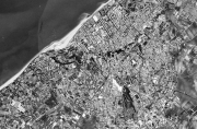
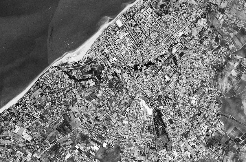
Ortofotografía Andalucía 1997-98 (SIG Oleícola)
Ortofoto de Andalucía de 1m, generada a partir de vuelo fotogramétrico Olistat BN 1:40.000 de 1997-98, para generar la Base de Referencia del proyeto SIG Oleícola. (V101_of)
Simple
- Date (Creation)
- 1998-01-01
- Date (Revision)
- 2008-02-29
- Presentation form
- Digital image
- Purpose
-
Disponibilidad de Bases Cartográficas de Referencia en la Comunidad Autónoma de Andalucía.
- Status
- Completed
- Point of contact
-
Organisation name Individual name Electronic mail address Role Consejería de Agricultura, Pesca y Medio Ambiente. Junta de Andalucía
Resource provider
-
Observación del Territorio
-
-
Observación del Territorio. Producto primario
-
- Theme
-
-
Fotografía aérea
-
Fotogrametría
-
Vuelo de bajo nivel
-
IDEAndalucia
-
Opendata
-
-
GEMET - INSPIRE themes, version 1.0
-
-
Ortoimágenes
-
- Use limitation
-
Para saber la licencia hay que mirar el campo de acceso y uso.
- Access constraints
- Other restrictions
- Use constraints
- Other restrictions
- Other constraints
-
Creative Commons Attribution 4.0 International Public License (CC BY 4.0)
- Spatial representation type
- Grid
- Language
- Spanish; Castilian
- Character set
- UTF8
- Topic category
-
- Imagery base maps earth cover
))
- Supplemental Information
-
01020101
- Reference system identifier
- EPSG:23030
- Reference system identifier
- INSPIRE RS registry / http://www.opengis.net/def/crs/EPSG/0/4258
- Distribution format
-
Name Version MrSID
ECW
- Units of distribution
-
Servicio WMS
- OnLine resource
-
Protocol Linkage Name OGC:WMS-1.3.0-http-get-map
http://www.juntadeandalucia.es/medioambiente/mapwms/REDIAM_Ortofoto_PAN_Sig_Oleicola_1997_98? REDIAM. WMS Ortofoto Digital Pancromática del SIG Oleícola de Andalucía de 1997-98
- Units of distribution
-
Ficha WMS
- OnLine resource
-
Protocol Linkage Name WWW:LINK-1.0-http--related
http://www.juntadeandalucia.es/medioambiente/site/rediam/menuitem.04dc44281e5d53cf8ca78ca731525ea0/?vgnextoid=3eab0cd43687a310VgnVCM1000001325e50aRCRD&vgnextchannel=867122ad8470f210VgnVCM1000001325e50aRCRD&vgnextfmt=rediam&lr=lang_es WMS Ortofoto Digital Pancromática del SIG Oleícola de Andalucía de 1997-98
- Units of distribution
-
Datos en descarga
- OnLine resource
-
Protocol Linkage Name WWW:LINK-1.0-http--related
http://descargasrediam.cica.es/repo/s/RUR?path=%2F01_CARACTERIZACION_TERRITORIO%2F02_BASES_REF_ORTOFOTOS_ORTOIMAGENES%2F01_ORTOFOTOS%2F01_PROYECTOS_REGIONALES%2F1997_98_AND_1m_V101_of Descarga Ortofotografía Andalucía 1997-98 (SIG Oleícola) (1997_98_AND_1m_V101_of)
- Hierarchy level
- Dataset
Conformance result
- Date (Publication)
- 2010-12-08
Citation identifier
- Explanation
-
Consultar el reglamento mencionado
- Pass
- Yes
- Statement
-
Para generar la ortofotografía se utiliza la información proporcionada por el vuelo fotogramétrico, el apoyo de campo, la aerotriangulación y el modelo digital de elevaciones.
- Description
-
Vuelo fotogramétrico analógico a partir de la escala 1:40.000 del año 1998-1999 en BN de la Consejería de Medio Ambiente.
- File identifier
- 182489a3-ec79-4057-a497-22ca75a3ed41 XML
- Metadata language
- Spanish; Castilian
- Character set
- UTF8
- Hierarchy level
- Dataset
- Date stamp
- 2022-09-01T11:35:35
- Metadata standard name
-
ISO 19115 "NEM"
- Metadata standard version
-
2003 "1.0"
- Metadata author
-
Organisation name Individual name Electronic mail address Role Consejería de Sostenibilidad, Medio Ambiente y Economía Azul. Junta de Andalucía
Author
Overviews
Spatial extent
Provided by
