 Catálogo REDIAM
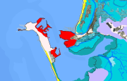
REDIAM. WMS Mapa de Unidades Fisiográficas del Litoral de Andalucía. Año 2003
Servicio WMS correspondiente al Mapa de las unidades fisiográficas del litoral andaluz que tienen relación, desde el punto de vista de su morfogénesis, con la dinámica litoral. Así mismo se incluyen algunas unidades no estrictamente litorales pero que por su localización constituyen una continuidad de las anteriores (unidades fluviales o fluvio-coluviales por ejemplo), así como los elementos antrópicos que en mayor o menor medida afectan a la configuración de estas unidades o a su evolución (puertos, espigones, etc.). La leyenda está estructurada jerárquicamente para facilitar la lectura cartográfica, de manera que a escalas menores de 1:150.000 se representan las unidades a un nivel básico y al aumentarse la escala a partir de 1:150.000 la desagregación de la leyenda y por tanto el nivel de detalle de la información aumenta. Nodo de la Red de Información Ambiental de Andalucía. Junta de Andalucía. Integrado en la Infraestructura de Datos Espaciales de Andalucía, siguiendo las directrices del Sistema Cartográfico de Andalucía.
Simple
- Date (Publication)
- 2013-01-17T11:39:46
- Status
- Completed
- Point of contact
-
Organisation name Individual name Electronic mail address Role Consejería de Medio Ambiente y Ordenación del Territorio. Junta de Andalucía
--
Point of contact
- Theme
-
-
WMS
-
REDIAM
-
Andalucía
-
Zonas costeras
-
Litoral
-
geomorfología
-
humanInteractionService
-
IDEAndalucia
-
- Use limitation
-
Este servicio se puede usar de modo libre y gratuito siempre que se mencione a los autores y propietarios de la información
- Access constraints
- Other restrictions
- Use constraints
- Other restrictions
- Other constraints
-
Creative Commons Reconocimiento 4.0 (CC BY 4.0)
- Service Type
- OGC:WMS
- Service Version
-
1.1.1
- Fees
-
Gratuito
))
- Coupling Type
- Tight
- Contains Operations
- Distribution format
-
Name Version WMS
1.1.1
- OnLine resource
-
Protocol Linkage Name OGC:WMS-1.1.1-http-get-map
http://www.juntadeandalucia.es/medioambiente/mapwms/REDIAM_Fisiografia_Litoral_Andaluz?
- OnLine resource
-
Protocol Linkage Name GLG:KML-2.0-http-get-map
http://www.juntadeandalucia.es/medioambiente/portal_web/rediam/productos/ServiciosOGC/KML/Cartografia_ambiental/Ambitos_interes_ambiental/unidades_fisiog_litoral_2003.kml KML servicio
- OnLine resource
-
Protocol Linkage Name WWW:LINK-1.0-http--link
http://www.juntadeandalucia.es/medioambiente/site/rediam/menuitem.04dc44281e5d53cf8ca78ca731525ea0/?vgnextoid=aef81cab5bf59210VgnVCM1000001325e50aRCRD&vgnextchannel=4a26fa937370f210VgnVCM1000001325e50aRCRD&vgnextfmt=rediam&lr=lang_es Ficha servicio Canal REDIAM
- Hierarchy level
- Service
Attributes
Conformance result
- Date (Publication)
- 2010-12-08
Citation identifier
- Explanation
-
Consultar el reglamento mencionado
- Pass
- Yes
- File identifier
- 255b3a17857936c31b735072b7a66ffe38c99a23 XML
- Metadata language
- Spanish; Castilian
- Character set
- UTF8
- Hierarchy level
- Service
- Date stamp
- 2022-09-02T06:07:55
- Metadata standard name
-
ISO 19119/2005
- Metadata standard version
-
1.0
- Metadata author
-
Organisation name Individual name Electronic mail address Role Consejería de Sostenibilidad, Medio Ambiente y Economía Azul. Junta de Andalucía
--
Point of contact
Overviews

Spatial extent
Provided by
