 Catálogo REDIAM
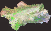
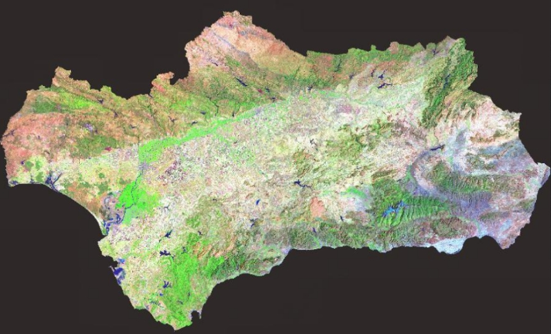
REDIAM. WMS Mosaico de ortoimágenes de Andalucía, 1991 (Landsat TM). Falso color (bandas 3,4,5)
Nodo de la Red de Información Ambiental de Andalucía. Junta de Andalucía.ervicio WMS correspondiente al mosaico de ortoimágenes Landsat TM (Thematic Mapper Data) de Andalucía, año 1991, de 30 metros de resolución espacial. Para la generación de dicho mosaico en falso color se utilizaron las bandas 3, 4 y 5 del conjunto de escenas Landsat. En ETRS89 UTM huso 30. Este mosaico puede ser utilizado como documento cartográfico y fuente de información, de cara a la producción de mapas temáticos (usos del suelo, láminas de agua, incendios forestales, cultivos, etc.) y a la actualización del mapa de usos y coberturas. Nodo de la Red de Información Ambiental de Andalucía. Junta de Andalucía. Integrado en la Infraestructura de Datos Espaciales de Andalucía, siguiendo las directrices del Sistema Cartográfico de Andalucía.
Simple
- Date (Revision)
- 2012-11-14T12:49:30
- Status
- Completed
- Point of contact
-
Organisation name Individual name Electronic mail address Role Consejería de Medio Ambiente y Ordenación del Territorio. Junta de Andalucía
--
Point of contact
- Theme
-
-
WMS
-
Andalucía
-
REDIAM
-
Landsat
-
teledetección
-
1991
-
humanInteractionService
-
IDEAndalucia
-
- Use limitation
-
Este servicio se puede usar de modo libre y gratuito siempre que se mencione a los autores y propietarios de la información
- Access constraints
- Other restrictions
- Use constraints
- Other restrictions
- Other constraints
-
Creative Commons Reconocimiento 4.0 (CC BY 4.0)
- Service Type
- OGC:WMS
- Service Version
-
1.1.1
- Fees
-
Gratuito
))
- Coupling Type
- Tight
- Contains Operations
-
Observación del Territorio
-
-
Observación del Territorio. Producto primario
-
- Distribution format
-
Name Version WMS
1.3.0
- OnLine resource
-
Protocol Linkage Name OGC:WMS-1.3.0-http-get-map
http://www.juntadeandalucia.es/medioambiente/mapwms/REDIAM_Landsat_Andalucia_1991?
- OnLine resource
-
Protocol Linkage Name GLG:KML-2.0-http-get-map
http://www.juntadeandalucia.es/medioambiente/portal_web/rediam/productos/ServiciosOGC/KML/Ortoimagenes/Regionales/landsat_1991.kml KML servicio
- OnLine resource
-
Protocol Linkage Name WWW:LINK-1.0-http--link
http://www.juntadeandalucia.es/medioambiente/site/rediam/menuitem.04dc44281e5d53cf8ca78ca731525ea0/?vgnextoid=707e8a06fd3ca110VgnVCM1000000624e50aRCRD&vgnextchannel=94e2d61d8470f210VgnVCM2000000624e50aRCRD&vgnextfmt=rediam&lr=lang_es Ficha servicio Canal REDIAM
- Hierarchy level
- Service
Attributes
Conformance result
- Date (Publication)
- 2010-12-08
Citation identifier
- Explanation
-
Consultar el reglamento mencionado
- Pass
- Yes
- File identifier
- 5220b346f97b60def6d3fdbf3ce4db8dc27a1385 XML
- Metadata language
- Spanish; Castilian
- Character set
- UTF8
- Hierarchy level
- Service
- Date stamp
- 2022-09-02T06:06:26
- Metadata standard name
-
ISO 19119/2005
- Metadata standard version
-
1.0
- Metadata author
-
Organisation name Individual name Electronic mail address Role Consejería de Sostenibilidad, Medio Ambiente y Economía Azul. Junta de Andalucía
--
Point of contact
Overviews
Spatial extent
Provided by
