 Catálogo REDIAM
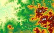
MDE de Sierra María-Los Vélez (Almería), 2010
Modelo Digital de Elevaciones, del ámbito de Sierra María-Los Vélez, compuesto por datos que expresan superficie y terreno, a partir de la clasificación de la nube de puntos en formato LAS de los datos adquiridos por el sensor LiDar, con resolución de 15cm de tamaño de pixel, realizado en 2008.(V180_el).
Simple
- Date (Creation)
- 2012-12-18
- Presentation form
- Digital model
- Purpose
-
Base de Cartográfica de Referencia Altimétrica y obtención un modelo a nivel del suelo a partir del cual se obtengan unas ortofotos correctas geométricamente.
- Status
- Historical archive
- Point of contact
-
Organisation name Individual name Electronic mail address Role Consejería de Medio Ambiente y Ordenación del Territorio. Junta de Andalucía
Author
-
Observación del Territorio
-
-
Observación del Territorio. Producto primario
-
- Theme
-
-
Fotografía aérea
-
Fotogrametría
-
Vuelo de bajo nivel
-
IDEAndalucia
-
Opendata
-
-
GEMET - INSPIRE themes, version 1.0
-
-
Elevaciones
-
-
Registro de temas REDIAM
-
-
Teledetección y caracterización del territorio
-
- Access constraints
- Other restrictions
- Use constraints
- Other restrictions
- Other constraints
-
Creative Commons Attribution 4.0 International Public License (CC BY 4.0)
- Spatial representation type
- Grid
- Language
- Spanish; Castilian
- Character set
- UTF8
- Topic category
-
- Elevation
))
- Supplemental Information
-
01070102
- Reference system identifier
- EPSG:25830
- Reference system identifier
- INSPIRE RS registry / http://www.opengis.net/def/crs/EPSG/0/4258
- Distribution format
-
Name Version TIFF
XYZ
- Units of distribution
-
Datos en descarga
- OnLine resource
-
Protocol Linkage Name WWW:LINK-1.0-http--link
https://portalrediam.cica.es/descargas?path=%2F01_CARACTERIZACION_TERRITORIO%2F07_BASES_REF_ELEV%2F01_ELEVACIONES%2F02_PROYECTOS_LOCALES%2F2010_Al_SMaria_V180_el descarga MDE de Sierra María-Los Vélez (Almería), 2010
- Hierarchy level
- Series
Conformance result
- Date (Publication)
- 2010-12-08
Citation identifier
- Explanation
-
Consultar el reglamento mencionado
- Pass
- Yes
- Statement
-
Toda información referente a los datos y los procesos correspondientes a las distintas fases que conlleva el proceso fotogramétrico como son: 1.Vuelo Fotogramétrico; 2.Vuelo fotogramétrico Lidar; 3.Apoyo de Campo; 4.Aerotriangulación; 5. Tratamiento Lidar; 6.Elevaciones; 7.Ortofoto Rigurosa; 8.Grabación; 9.Control de Calidad; 10.Entrega; 11.Seguimiento; 12.Otros; 13.Pliegos.
- Description
-
Vuelo Fotogramétrico Digital y Vuelo LiDar
- File identifier
- 6985554c-17e2-4e96-a2db-e54ca662bb1b XML
- Metadata language
- Spanish; Castilian
- Character set
- UTF8
- Hierarchy level
- Dataset
- Date stamp
- 2022-10-20T08:44:48
- Metadata standard name
-
ISO 19115 "NEM"
- Metadata standard version
-
2003 "1.0"
- Metadata author
-
Organisation name Individual name Electronic mail address Role Consejería de Sostenibilidad, Medio Ambiente y Economía Azul. Junta de Andalucía
Author
Overviews

Spatial extent
Provided by
