 Catálogo REDIAM
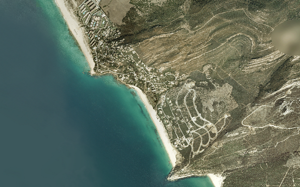
Ortofotografía Cuadrante NW de Andalucía, 2009
Ortofoto del Cuadrante NW con resolución 0.5 m. se utiliza la información proporcionada por el vuelo fotogramétrico de 2009, el apoyo de campo, la aerotriangulación y el modelo digital de elevaciones. Realizada por la Junta de Andalucía (CVOT) y Ministerio de Fomento (IGN). (V181_of)
Simple
- Date (Creation)
- 2010-03-17
- Presentation form
- Digital image
- Purpose
-
Disponibilidad de Base de referencia cartográfica con escasa resolución geométrica, es una ortofoto rápida con limitaciones de uso según las necesidades.
- Status
- Completed
- Point of contact
-
Organisation name Individual name Electronic mail address Role Consejería de Agricultura, Pesca y Medio Ambiente. Junta de Andalucía
Owner
-
Observación del Territorio
-
-
Observación del Territorio. Producto primario
-
- Theme
-
-
Fotografía aérea
-
Fotogrametría
-
IDEAndalucia
-
Opendata
-
-
GEMET - INSPIRE themes, version 1.0
-
-
Ortoimágenes
-
- Access constraints
- Other restrictions
- Use constraints
- Other restrictions
- Other constraints
-
Creative Commons Attribution 4.0 International Public License (CC BY 4.0)
- Spatial representation type
- Grid
- Language
- Spanish; Castilian
- Character set
- UTF8
- Topic category
-
- Imagery base maps earth cover
))
- Supplemental Information
-
01020101
- Reference system identifier
- EPSG:25830
- Reference system identifier
- INSPIRE RS registry / http://www.opengis.net/def/crs/EPSG/0/4258
- Distribution format
-
Name Version JP2
- Units of distribution
-
Servicio WMS
- OnLine resource
-
Protocol Linkage Name OGC:WMS-1.3.0-http-get-map
http://www.juntadeandalucia.es/medioambiente/mapwms/REDIAM_Ortofoto_Andalucia_RGB_2008_2009? REDIAM. Ortofoto de Andalucía color (RGB) de 2008-2009
- Units of distribution
-
Datos en descarga
- OnLine resource
-
Protocol Linkage Name WWW:LINK-1.0-http--related
http://descargasrediam.cica.es/repo/s/RUR?path=%2F01_CARACTERIZACION_TERRITORIO%2F02_BASES_REF_ORTOFOTOS_ORTOIMAGENES%2F01_ORTOFOTOS%2F01_PROYECTOS_REGIONALES%2F2009_AND_NW_0.5m_V181_of Descarga Ortofotografía Cuadrante NW de Andalucía, 2009 (2009_AND_NW_0.5m_V181_of)
- Hierarchy level
- Dataset
Conformance result
- Date (Publication)
- 2010-12-08
Citation identifier
- Explanation
-
Consultar el reglamento mencionado
- Pass
- Yes
- Statement
-
Para generar la ortofotografía se utiliza la información proporcionada por el vuelo fotogramétrico, el apoyo de campo, la aerotriangulación y el modelo digital de elevaciones.
- Description
-
Para generar la ortofotografía rápida se utiliza la información proporcionada por el vuelo fotogramétrico, relativa a datos GPS y el modelo digital de elevaciones.
- Description
-
Vuelo fotogramétrico digital a 0.5 m. del año 2009 de la Consejería de Medio Ambiente.
- File identifier
- 725f19f7-62f4-42db-b3f1-c161e4861d4a XML
- Metadata language
- Spanish; Castilian
- Character set
- UTF8
- Hierarchy level
- Dataset
- Date stamp
- 2022-09-01T11:40:10Z
- Metadata standard name
-
ISO 19115 "NEM"
- Metadata standard version
-
2003 "1.0"
- Metadata author
-
Organisation name Individual name Electronic mail address Role Consejería de Sostenibilidad, Medio Ambiente y Economía Azul. Junta de Andalucía
Originator
Overviews

Spatial extent
Provided by
