 Catálogo REDIAM
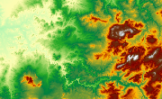
MDE Cuadrante SE de Andalucía, 2004 (10x10m)
Modelo Digital de Elevaciones: Terreno (MDT) del cuadrante SE de Andalucía generado a partir del vuelo fotogramétrico infrarrojo color (0,30m), con escala 1:20.000 de 2004. (V008_el).
Simple
- Date (Creation)
- 2004-01-01
- Date (Revision)
- 2008-02-29
- Citation identifier
- Sin identificador
- Presentation form
- Digital model
- Purpose
-
Base de Cartográfica de Referencia Altimétrica y obtención un modelo a nivel del suelo a partir del cual se obtengan unas ortofotos correctas geométricamente
- Status
- Historical archive
- Point of contact
-
Organisation name Individual name Electronic mail address Role Consejería de Medio Ambiente y Ordenación del Territorio. Junta de Andalucía
Owner
-
Observación del Territorio
-
-
Observación del Territorio. Producto primario
-
- Theme
-
-
Fotografía aérea
-
Fotogrametría
-
Vuelo de bajo nivel
-
IDEAndalucia
-
-
GEMET - INSPIRE themes, version 1.0
-
-
Elevaciones
-
-
Registro de temas REDIAM
-
-
Teledetección y caracterización del territorio
-
- Use limitation
-
Para saber la licencia hay que mirar el campo de acceso y uso.
- Access constraints
- Other restrictions
- Use constraints
- Other restrictions
- Spatial representation type
- Grid
- Language
- Spanish; Castilian
- Character set
- UTF8
- Topic category
-
- Elevation
))
- Supplemental Information
-
01070101
- Reference system identifier
- EPSG:25830
- Reference system identifier
- INSPIRE RS registry / http://www.opengis.net/def/crs/EPSG/0/4258
- Distribution format
-
Name Version GRID
TIFF
ASCIIXYZ
- Units of distribution
-
Datos en descarga
- OnLine resource
-
Protocol Linkage Name WWW:LINK-1.0-http--link
https://portalrediam.cica.es/descargas?path=%2F01_CARACTERIZACION_TERRITORIO%2F07_BASES_REF_ELEV%2F01_ELEVACIONES%2F01_PROYECTOS_REGIONALES%2F2004_AND_SE_10m_V008_el Descarga MDE Cuadrante SE de Andalucía, 2004 (10x10m)
- Hierarchy level
- Series
Conformance result
- Date (Publication)
- 2010-12-08
Citation identifier
- Explanation
-
Consultar el reglamento mencionado
- Pass
- Yes
- Statement
-
Para generar el modelo digital de elevaciones se parte del vuelo fotogramétrico con información GPS e IMU, el apoyo de campo y se lleva a cabo la aerotriangulación por bloques establecidos en el proyecto ORTO_AND (PNOA). A partir de estos datos, se van seguir las siguientes fases: -Generación de líneas de ruptura -Generación del modelo digital por correlación - Generación de MDS por fusión de líneas de ruptura y estructura con la malla de correlación editada - Generación de MDT reduciendo al terreno el MDS.
- Description
-
Generado a partir del vuelo fotogramétrico analógico a escala 1:20.000 en Infrarrojo-Color del cuadrante SE en los año 2004 de la CMA, COPT(ICA), DAP y el IGN.
- File identifier
- c0b34b34-e221-485e-a720-c11d492eed32 XML
- Metadata language
- Spanish; Castilian
- Character set
- UTF8
- Hierarchy level
- Series
- Date stamp
- 2022-10-20T09:14:17
- Metadata standard name
-
ISO 19115 "NEM"
- Metadata standard version
-
2003 "1.0"
- Metadata author
-
Organisation name Individual name Electronic mail address Role Consejería de Sostenibilidad, Medio Ambiente y Economía Azul. Junta de Andalucía
Author
Overviews

Spatial extent
Provided by
