• Catálogo REDIAM
  •  
  •  
  •  

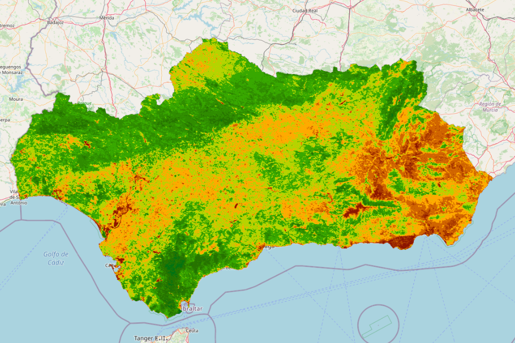
REDIAM. WMS Serie de imágenes de satélite TERRA MODIS. NDVI (Normaliced Difference Vegetation Index) medio anual. Año 2021. 250 m. Andalucía.

Servicio WMS correspondiente a la imagen de satélite TERRA MODIS media anual de NDVI correspondiente al año 2021. Resolución espacial 250 m. Ámbito de Andalucía. En ETRS89 UTM huso 30. Para el seguimiento del estado de la vegetación forestal y cultivada a escala regional. Nodo de la Red de Información Ambiental de Andalucía. Junta de Andalucía. Integrado en la Infraestructura de Datos Espaciales de Andalucía, siguiendo las directrices del Sistema Cartográfico de Andalucía.

Simple

Date (Publication)
2022-02-18T12:51:09
Status
Completed
Point of contact
Organisation name Individual name Electronic mail address Role

Consejería de Agricultura, Ganadería, Pesca y Desarrollo Sostenible. Junta de Andalucía

--

rediam.atiende.cagpds@juntadeandalucia.es

Point of contact

GEMET INSPIRE themes

  • Ortoimágenes

Theme
  • WMS

  • Andalucía

  • REDIAM

  • Imagen de satélite

  • sensor

  • satélite de observación

  • teledetección

  • vegetación

  • IDEAndalucia

INSPIRE glossary

  • Interoperabilidad

GEMET - INSPIRE themes, version 1.0

  • Ortoimágenes

Registro de temas REDIAM

  • Biodiversidad y Vegetación

Access constraints
Other restrictions
Other constraints

Este servicio se puede usar de modo libre y gratuito siempre que se mencione a los autores y propietarios de la información

Service Type
OGC:WMS
Service Version

1.3.0

Fees

Gratuito

N
S
E
W
thumbnail


Coupling Type
Tight
Contains Operations
Operation Name Distributed Computing Platforms Connect Point

GetCapabilities

HTTP-GET HTTP-POST https://www.juntadeandalucia.es/medioambiente/mapwms/REDIAM_terra_modis_ndvi_anual_2021?

GetMap

HTTP-GET HTTP-POST https://www.juntadeandalucia.es/medioambiente/mapwms/REDIAM_terra_modis_ndvi_anual_2021? https://www.juntadeandalucia.es/medioambiente/mapwms/REDIAM_terra_modis_ndvi_anual_2021? https://www.juntadeandalucia.es/medioambiente/mapwms/REDIAM_terra_modis_ndvi_anual_2021? https://www.juntadeandalucia.es/medioambiente/mapwms/REDIAM_terra_modis_ndvi_anual_2021? https://www.juntadeandalucia.es/medioambiente/mapwms/REDIAM_terra_modis_ndvi_anual_2021? https://www.juntadeandalucia.es/medioambiente/mapwms/REDIAM_terra_modis_ndvi_anual_2021? https://www.juntadeandalucia.es/medioambiente/mapwms/REDIAM_terra_modis_ndvi_anual_2021? https://www.juntadeandalucia.es/medioambiente/mapwms/REDIAM_terra_modis_ndvi_anual_2021? https://www.juntadeandalucia.es/medioambiente/mapwms/REDIAM_terra_modis_ndvi_anual_2021?

GetFeatureInfo

HTTP-GET HTTP-POST https://www.juntadeandalucia.es/medioambiente/mapwms/REDIAM_terra_modis_ndvi_anual_2021? https://www.juntadeandalucia.es/medioambiente/mapwms/REDIAM_terra_modis_ndvi_anual_2021? https://www.juntadeandalucia.es/medioambiente/mapwms/REDIAM_terra_modis_ndvi_anual_2021?

sld:DescribeLayer

HTTP-GET HTTP-POST https://www.juntadeandalucia.es/medioambiente/mapwms/REDIAM_terra_modis_ndvi_anual_2021?

sld:GetLegendGraphic

HTTP-GET HTTP-POST https://www.juntadeandalucia.es/medioambiente/mapwms/REDIAM_terra_modis_ndvi_anual_2021? https://www.juntadeandalucia.es/medioambiente/mapwms/REDIAM_terra_modis_ndvi_anual_2021? https://www.juntadeandalucia.es/medioambiente/mapwms/REDIAM_terra_modis_ndvi_anual_2021? https://www.juntadeandalucia.es/medioambiente/mapwms/REDIAM_terra_modis_ndvi_anual_2021? https://www.juntadeandalucia.es/medioambiente/mapwms/REDIAM_terra_modis_ndvi_anual_2021?

ms:GetStyles

HTTP-GET HTTP-POST https://www.juntadeandalucia.es/medioambiente/mapwms/REDIAM_terra_modis_ndvi_anual_2021?

Observación del Territorio

  • Observación del Territorio. Producto derivado

Distribution format
Name Version
OnLine resource
Protocol Linkage Name

OGC:WMS-1.3.0-http-get-map

https://www.juntadeandalucia.es/medioambiente/mapwms/REDIAM_terra_modis_ndvi_anual_2021?
Hierarchy level
Service

Attributes

No information provided.
File identifier
e3c5a4aa111a38f4580412f9d3306c98545c7f67 XML
Metadata language
Spanish; Castilian
Character set
UTF8
Parent identifier

5f172f3d-9f39-444c-a3c8-26b97f562834

Hierarchy level
Service
Date stamp
2022-09-22T09:36:19
Metadata standard name

ISO 19119/2005

Metadata standard version

1.0

Metadata author
Organisation name Individual name Electronic mail address Role

Consejería de Sostenibilidad, Medio Ambiente y Economía Azul. Junta de Andalucía.

--

rediam.atiende.cagpds@juntadeandalucia.es

Point of contact


Overviews

overview

Spatial extent

N
S
E
W
thumbnail


Keywords

Andalucía IDEAndalucia Imagen de satélite REDIAM WMS satélite de observación sensor teledetección vegetación
GEMET - INSPIRE themes, version 1.0
Ortoimágenes
GEMET INSPIRE themes
Ortoimágenes
INSPIRE glossary
Interoperabilidad
Observación del Territorio
Observación del Territorio. Producto derivado
Registro de temas REDIAM
Biodiversidad y Vegetación

Provided by

logo

Share on social sites

Access to the portal
Read here the full details and access to the data.

Associated resources

Not available


  •  
  •  
  •