 Catálogo REDIAM
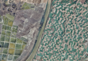
Ortofotografía Cuadrante SW de Andalucía, 2006
Ortofoto del cuadrante SW de Andalucía de 0.5m de resolución, generada a partir de un vuelo fotogramétrico digital de 0.30m de resolución, desarrollada en el marco de colaboración entre la Junta de Andalucía y el IGN. (V010_of)
Simple
- Date (Creation)
- 2008-07-03
- Date (Revision)
- 2008-02-29
- Presentation form
- Digital image
- Purpose
-
Disponibilidad de Bases Cartográficas de Referencia de la Comunidad Autónoma de Andalucía, desarrollada en el marco de la Colaboración entre la Junta de Andalucía (CVOT-CAP-CAM) y el Ministerio de Fomento (IGN).
- Status
- Historical archive
- Point of contact
-
Organisation name Individual name Electronic mail address Role Consejería de Medio Ambiente. Junta de Andalucía
Owner
-
Observación del Territorio
-
-
Observación del Territorio. Producto primario
-
- Theme
-
-
Fotografía aérea
-
Fotogrametría
-
IDEAndalucia
-
Opendata
-
-
GEMET - INSPIRE themes, version 1.0
-
-
Ortoimágenes
-
- Use limitation
-
Para saber la licencia hay que mirar el campo de acceso y uso.
- Access constraints
- Other restrictions
- Use constraints
- Other restrictions
- Other constraints
-
Creative Commons Attribution 4.0 International Public License (CC BY 4.0)
- Spatial representation type
- Grid
- Language
- Spanish; Castilian
- Character set
- UTF8
- Topic category
-
- Imagery base maps earth cover
))
- Supplemental Information
-
01020101
- Reference system identifier
- EPSG:25830
- Reference system identifier
- INSPIRE RS registry / http://www.opengis.net/def/crs/EPSG/0/4258
- Distribution format
-
Name Version JP2
Shape
- Units of distribution
-
Servicio WMS
- OnLine resource
-
Protocol Linkage Name OGC:WMS-1.3.0-http-get-map
https://www.juntadeandalucia.es/medioambiente/portal/web/guest/landing-page-servicio-ogc/-/asset_publisher/1qlWV3LW9vV6/content/rediam.-wms-ortofoto-del-cuadrante-suroeste-de-andaluc-c3-ada-de-0.5m-en-color-a-c3-b1o-de-vuelo-2006-/20151 REDIAM. Ortofoto del Cuadrante Suroeste de Andalucía, de 0,5m en Color (Año de Vuelo 2006).
- Units of distribution
-
Servicio WMS
- OnLine resource
-
Protocol Linkage Name OGC:WMS-1.3.0-http-get-map
https://www.juntadeandalucia.es/medioambiente/portal/web/guest/landing-page-servicio-ogc/-/asset_publisher/1qlWV3LW9vV6/content/rediam.-wms-ortofoto-del-cuadrante-suroeste-de-andaluc-c3-ada-de-0-5m-en-color-infrarrojo-a-c3-b1o-de-vuelo-2006-./20151 REDIAM. Ortofoto del Cuadrante Suroeste de Andalucía, de 0,5m en Infrarrojo Color (Año de Vuelo 2006)
OnLine resource
OnLine resource
- Units of distribution
-
Datos en descarga
- OnLine resource
-
Protocol Linkage Name WWW:LINK-1.0-http--related
http://descargasrediam.cica.es/repo/s/RUR?path=%2F01_CARACTERIZACION_TERRITORIO%2F02_BASES_REF_ORTOFOTOS_ORTOIMAGENES%2F01_ORTOFOTOS%2F01_PROYECTOS_REGIONALES%2F2006_AND_SW_0.5m_V010_of Descarga Ortofotografía Cuadrante SW de Andalucía, 2006 (2006_AND_SW_0.5m_V010_of)
- Hierarchy level
- Series
Conformance result
- Date (Publication)
- 2010-12-08
Citation identifier
- Explanation
-
Consultar el reglamento mencionado
- Pass
- Yes
- Statement
-
Para generar la ortofotografía se utiliza la información proporcionada por el vuelo fotogramétrico, el apoyo de campo, la aerotriangulación y el modelo digital de elevaciones.
- Description
-
Vuelo fotogramétrico digital a 0.45 m. del año 2006 de la Junta de Andalucía (CVOT-CAP-CMA).
- File identifier
- f29ef3c0-0574-435d-98e1-9735ac2c219d XML
- Metadata language
- Spanish; Castilian
- Character set
- UTF8
- Hierarchy level
- Dataset
- Date stamp
- 2022-09-01T09:22:07
- Metadata standard name
-
ISO 19115 "NEM"
- Metadata standard version
-
2003 "1.0"
- Metadata author
-
Organisation name Individual name Electronic mail address Role Consejería de Sostenibilidad, Medio Ambiente y Economía Azul. Junta de Andalucía
Author
Overviews
Spatial extent
Provided by
