 Catálogo REDIAM
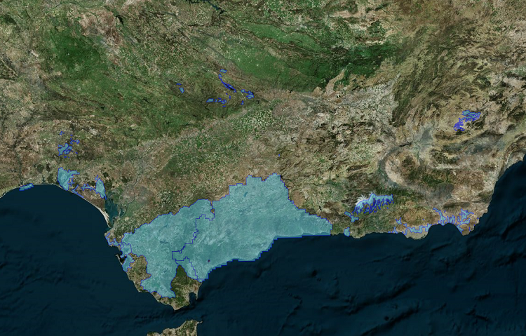
Localización geográfica de datos LiDAR de ámbitos locales de Andalucía
Localización geográfica de los datos LiDAR (nubes de puntos LAS) disponibles en la REDIAM, de proyectos sobre ámbitos locales. Delimitaciones de ámbitos cubiertos con datos LiDAR en formato vectorial y en el sistema de referencia ETRS89. (031V_el)
Simple
- Date (Creation)
- 2013-06-06
- Presentation form
- Digital map
- Purpose
-
Disponibilidad de localización de coberturas, fechas, y características técnicas de los productos disponibles.
- Status
- Historical archive
- Point of contact
-
Organisation name Individual name Electronic mail address Role Consejería de Medio Ambiente y Ordenación del Territorio. Junta de Andalucía
Author
-
Observación del Territorio
-
-
Observación del Territorio. Producto primario
-
- Theme
-
-
Proyección cartográfica
-
IDEAndalucia
-
LiDAR
-
-
GEMET - INSPIRE themes, version 1.0
-
-
Elevaciones
-
-
Registro de temas REDIAM
-
-
Teledetección y caracterización del territorio
-
- Use limitation
-
Para saber la licencia hay que mirar el campo de acceso y uso.
- Access constraints
- Other restrictions
- Use constraints
- Other restrictions
- Spatial representation type
- Vector
- Denominator
- 1000
- Language
- Spanish; Castilian
- Character set
- UTF8
- Topic category
-
- Boundaries
- Elevation
- Imagery base maps earth cover
))
- Supplemental Information
-
01030302
- Reference system identifier
- EPSG:25830
- Reference system identifier
- INSPIRE RS registry / http://www.opengis.net/def/crs/EPSG/0/25830
- Distribution format
-
Name Version Shape
- Units of distribution
-
Servicio WMS
- OnLine resource
-
Protocol Linkage Name http://www.juntadeandalucia.es/medioambiente/mapwms/REDIAM_Delimitacion_Local_Lidar? WMS Localización geográfica de datos LiDAR de ámbito local
- Units of distribution
-
Ficha WMS
- OnLine resource
-
Protocol Linkage Name http://www.juntadeandalucia.es/medioambiente/site/rediam/menuitem.04dc44281e5d53cf8ca78ca731525ea0/?vgnextoid=6665d5388f604410VgnVCM2000000624e50aRCRD&vgnextchannel=33be7c119370f210VgnVCM2000000624e50aRCRD&vgnextfmt=rediam&lr=lang_es WMS Localización geográfica de datos LiDAR de ámbito local
- Units of distribution
-
Datos en descarga
- OnLine resource
-
Protocol Linkage Name WWW:LINK-1.0-http--link
https://portalrediam.cica.es/descargas?path=%2F01_CARACTERIZACION_TERRITORIO%2F03_SENSORES_AEREOTRANSPORTADOS%2F03_LIDAR%2F02_PROYECTOS_LOCALES%2FDelimitacion_LAS_031V_las Ruta Repositorio de Información Ambiental: \01_CARACTERIZACION_TERRITORIO\03_SENSORES_AEREOTRANSPORTADOS\03_LIDAR\02_PROYECTOS_LOCALES\Delimitacion_LAS_031V_las
- Units of distribution
-
Publicación web
- OnLine resource
-
Protocol Linkage Name WWW:LINK-1.0-http--link
https://www.juntadeandalucia.es/medioambiente/portal/web/guest/acceso-rediam/teledeteccion-y-caracterizacion-territorio/bases-de-referencia-cartografica/cobertura-lidar Cobertura LiDAR
- Hierarchy level
- Dataset
Conformance result
- Date (Publication)
- 2010-12-08
Citation identifier
- Explanation
-
Consultar el reglamento mencionado
- Pass
- Yes
- Statement
-
La capa de información vectorial en formato shape está revisada y no tiene errores topológicos.
- File identifier
- c11fef97-2ca7-4c47-b953-37456b7e9eb5 XML
- Metadata language
- Spanish; Castilian
- Character set
- UTF8
- Hierarchy level
- Dataset
- Date stamp
- 2024-11-28T09:54:25.167Z
- Metadata standard name
-
ISO 19115 "NEM"
- Metadata standard version
-
2003 "1.0"
- Metadata author
-
Organisation name Individual name Electronic mail address Role Consejería de Sostenibilidad y Medio Ambiente. Junta de Andalucía
Author
Overviews
Spatial extent
Provided by
