 Catálogo REDIAM
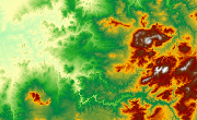
MDE Costa Occidental de Huelva, 2007
Modelo Digital de Elevaciones: Terreno (MDT) del ámbito de la Costa de Huelva Occidental generado a partir de vuelo Lidar (1m) de 2007. (V146_el)
Simple
- Date (Creation)
- 2009-02-06
- Presentation form
- Digital model
- Purpose
-
Base de Cartográfica de Referencia Altimétrica y obtención un modelo a nivel del suelo a partir del cual se obtengan unas ortofotos correctas geométricamente.
- Status
- Historical archive
- Point of contact
-
Organisation name Individual name Electronic mail address Role Agencia Andaluza del Agua. Consejería de Medio Ambiente. Junta de Andalucía
Author
-
Observación del Territorio
-
-
Observación del Territorio. Producto primario
-
- Theme
-
-
Fotografía aérea
-
Fotogrametría
-
Vuelo de bajo nivel
-
IDEAndalucia
-
Opendata
-
-
GEMET - INSPIRE themes, version 1.0
-
-
Elevaciones
-
-
Registro de temas REDIAM
-
-
Teledetección y caracterización del territorio
-
- Access constraints
- Other restrictions
- Use constraints
- Other restrictions
- Other constraints
-
Creative Commons Attribution 4.0 International Public License (CC BY 4.0)
- Spatial representation type
- Grid
- Language
- Spanish; Castilian
- Character set
- UTF8
- Topic category
-
- Elevation
))
- Supplemental Information
-
01070102
- Reference system identifier
- EPSG:25830
- Reference system identifier
- INSPIRE RS registry / http://www.opengis.net/def/crs/EPSG/0/4258
- Distribution format
-
Name Version TIFF
ASCIIXYZ
- Units of distribution
-
Datos en descarga
- OnLine resource
-
Protocol Linkage Name WWW:LINK-1.0-http--link
https://portalrediam.cica.es/descargas?path=%2F01_CARACTERIZACION_TERRITORIO%2F07_BASES_REF_ELEV%2F01_ELEVACIONES%2F02_PROYECTOS_LOCALES%2F2007_09_23_HU_Costa_V147_el Descarga MDE Costa Occidental de Huelva, 2007
- Hierarchy level
- Dataset
Conformance result
- Date (Publication)
- 2010-12-08
Citation identifier
- Explanation
-
Consultar el reglamento mencionado
- Pass
- Yes
- Statement
-
Para generar el modelo digital de elevaciones se parte del vuelo LIDAR con la información GPS e IMU y se procesan los datos capturados con el sensor. A partir de los datos brutos se realiza una clasificación de puntos. Con los puntos clasificados como terreno se genera el MDT grid. Con éstos más edificios, infraestructuras,... Se genera el MDS grid.
- Description
-
Generado a partir del vuelo fotogramétrico esclavo (digital + lidar) de 1m de resolución de la Consejería de Medio Ambiente.
- File identifier
- f1f3dab9-2741-41a6-bf42-4489c696610f XML
- Metadata language
- Spanish; Castilian
- Character set
- UTF8
- Hierarchy level
- Dataset
- Date stamp
- 2022-10-20T09:22:38
- Metadata standard name
-
ISO 19115 "NEM"
- Metadata standard version
-
2003 "1.0"
- Metadata author
-
Organisation name Individual name Electronic mail address Role Consejería de Sostenibilidad, Medio Ambiente y Economía Azul. Junta de Andalucía
Author
Overviews

Spatial extent
Provided by
